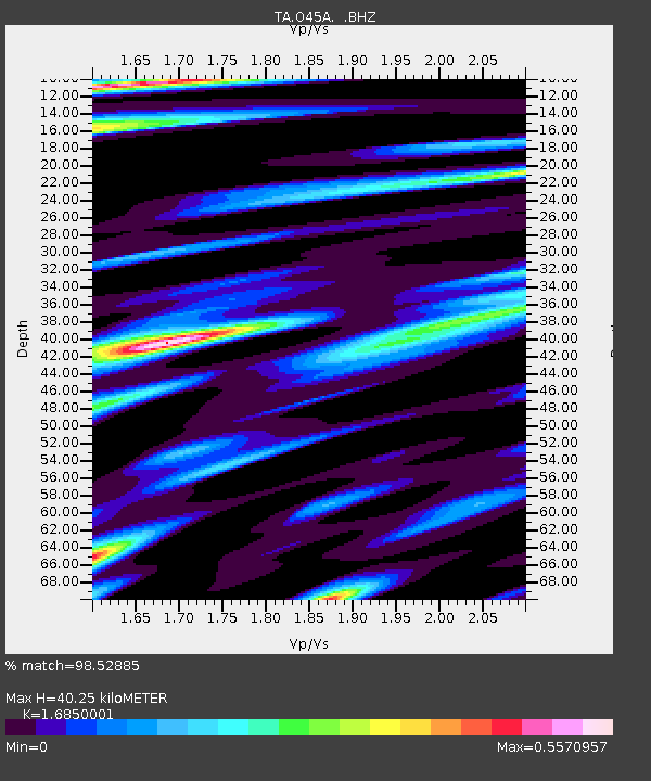
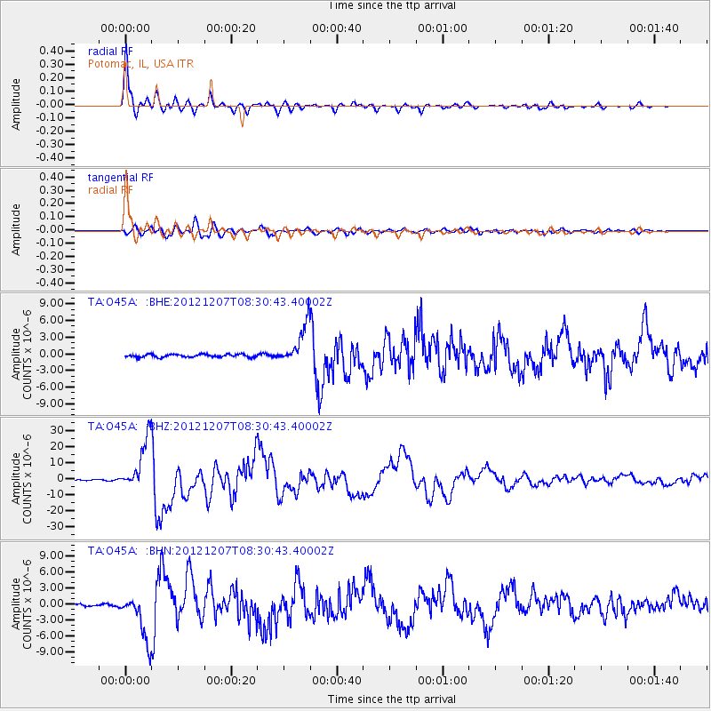
O45A Potomac, IL, USA - Earthquake Result Viewer

Earthquake location: Off East Coast Of Honshu, Japan
Earthquake latitude/longitude: 37.9/143.9
Earthquake time(UTC): 2012/12/07 (342) 08:18:23 GMT
Earthquake Depth: 31 km
Earthquake Magnitude: 7.2 MB, 7.3 MS, 7.3 MW, 7.3 MW
Earthquake Catalog/Contributor: WHDF/NEIC
Network: TA USArray Transportable Network (new EarthScope stations)
Station: O45A Potomac, IL, USA
Lat/Lon: 40.25 N/87.72 W
Elevation: 208 m
Distance: 89.0 deg
Az: 36.908 deg
Baz: 321.627 deg
Ray Param: 0.042157717
Estimated Moho Depth: 40.25 km
Estimated Crust Vp/Vs: 1.69
Assumed Crust Vp: 6.498 km/s
Estimated Crust Vs: 3.856 km/s
Estimated Crust Poisson's Ratio: 0.23
Radial Match: 98.52885 %
Radial Bump: 366
Transverse Match: 89.962265 %
Transverse Bump: 400
SOD ConfigId: 488671
Insert Time: 2013-03-29 04:41:25.119 +0000
GWidth: 2.5
Max Bumps: 400
Tol: 0.001

Signal To Noise

ChannelStoNSTALTA
TA:O45A: :BHZ:20121207T08:30:43.40002Z53.7601171.6179507E-53.0095742E-7
TA:O45A: :BHN:20121207T08:30:43.40002Z17.1441214.383849E-62.5570566E-7
TA:O45A: :BHE:20121207T08:30:43.40002Z13.6499743.6075653E-62.64291E-7
Arrivals
Ps4.3 SECOND
PpPs16 SECOND
PsPs/PpSs21 SECOND