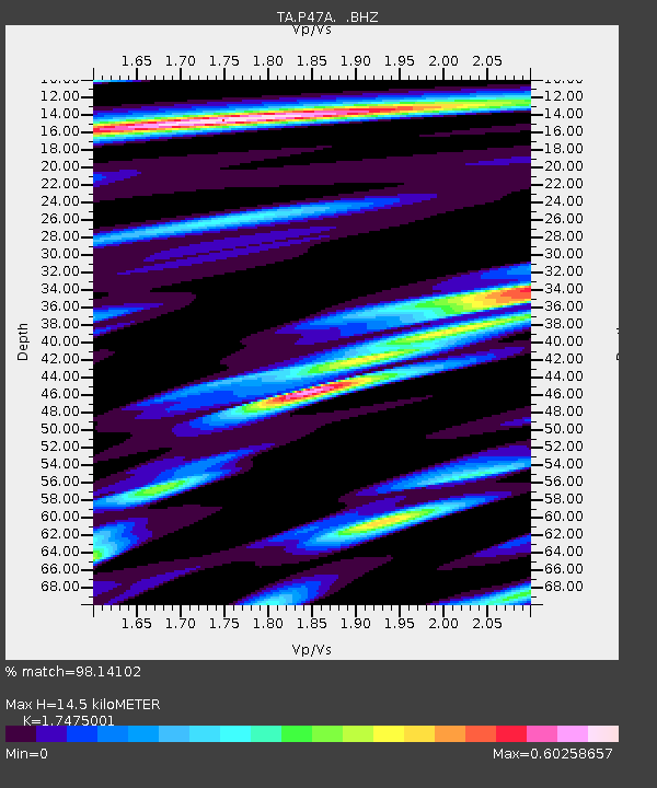
P47A Martinsville, IN, USA - Earthquake Result Viewer
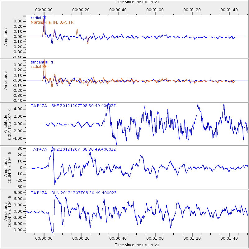
Earthquake location: Off East Coast Of Honshu, Japan
Earthquake latitude/longitude: 37.9/143.9
Earthquake time(UTC): 2012/12/07 (342) 08:18:23 GMT
Earthquake Depth: 31 km
Earthquake Magnitude: 7.2 MB, 7.3 MS, 7.3 MW, 7.3 MW
Earthquake Catalog/Contributor: WHDF/NEIC
Network: TA USArray Transportable Network (new EarthScope stations)
Station: P47A Martinsville, IN, USA
Lat/Lon: 39.49 N/86.27 W
Elevation: 246 m
Distance: 90.3 deg
Az: 36.492 deg
Baz: 322.553 deg
Ray Param: 0.041682933
Estimated Moho Depth: 14.5 km
Estimated Crust Vp/Vs: 1.75
Assumed Crust Vp: 6.444 km/s
Estimated Crust Vs: 3.687 km/s
Estimated Crust Poisson's Ratio: 0.26
Radial Match: 98.14102 %
Radial Bump: 400
Transverse Match: 94.076836 %
Transverse Bump: 400
SOD ConfigId: 488671
Insert Time: 2013-03-29 04:41:34.773 +0000
GWidth: 2.5
Max Bumps: 400
Tol: 0.001

Signal To Noise

ChannelStoNSTALTA
TA:P47A: :BHZ:20121207T08:30:49.40002Z53.412581.4896044E-52.7888646E-7
TA:P47A: :BHN:20121207T08:30:49.40002Z21.0221234.457177E-62.1202317E-7
TA:P47A: :BHE:20121207T08:30:49.40002Z7.1424372.2533038E-63.1548112E-7
Arrivals
Ps1.7 SECOND
PpPs6.1 SECOND
PsPs/PpSs7.8 SECOND