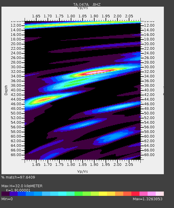
O47A Sheridan, IN, USA - Earthquake Result Viewer
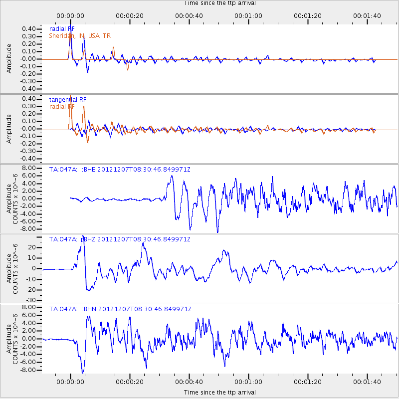
Earthquake location: Off East Coast Of Honshu, Japan
Earthquake latitude/longitude: 37.9/143.9
Earthquake time(UTC): 2012/12/07 (342) 08:18:23 GMT
Earthquake Depth: 31 km
Earthquake Magnitude: 7.2 MB, 7.3 MS, 7.3 MW, 7.3 MW
Earthquake Catalog/Contributor: WHDF/NEIC
Network: TA USArray Transportable Network (new EarthScope stations)
Station: O47A Sheridan, IN, USA
Lat/Lon: 40.24 N/86.17 W
Elevation: 278 m
Distance: 89.7 deg
Az: 35.979 deg
Baz: 322.614 deg
Ray Param: 0.04172215
Estimated Moho Depth: 32.0 km
Estimated Crust Vp/Vs: 1.91
Assumed Crust Vp: 6.498 km/s
Estimated Crust Vs: 3.402 km/s
Estimated Crust Poisson's Ratio: 0.31
Radial Match: 97.6409 %
Radial Bump: 394
Transverse Match: 91.664444 %
Transverse Bump: 400
SOD ConfigId: 488671
Insert Time: 2013-03-29 04:41:46.322 +0000
GWidth: 2.5
Max Bumps: 400
Tol: 0.001

Signal To Noise

ChannelStoNSTALTA
TA:O47A: :BHZ:20121207T08:30:46.849971Z48.944031.5244372E-53.114654E-7
TA:O47A: :BHN:20121207T08:30:46.849971Z14.0754354.053848E-62.8800872E-7
TA:O47A: :BHE:20121207T08:30:46.849971Z12.7875243.0480307E-62.3835973E-7
Arrivals
Ps4.6 SECOND
PpPs14 SECOND
PsPs/PpSs19 SECOND