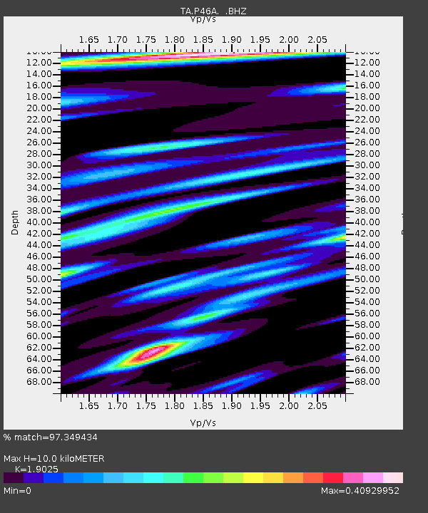
P46A Rosedale, IN, USA - Earthquake Result Viewer
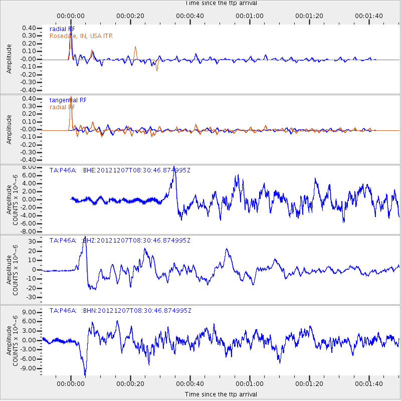
Earthquake location: Off East Coast Of Honshu, Japan
Earthquake latitude/longitude: 37.9/143.9
Earthquake time(UTC): 2012/12/07 (342) 08:18:23 GMT
Earthquake Depth: 31 km
Earthquake Magnitude: 7.2 MB, 7.3 MS, 7.3 MW, 7.3 MW
Earthquake Catalog/Contributor: WHDF/NEIC
Network: TA USArray Transportable Network (new EarthScope stations)
Station: P46A Rosedale, IN, USA
Lat/Lon: 39.62 N/87.21 W
Elevation: 194 m
Distance: 89.7 deg
Az: 36.985 deg
Baz: 321.959 deg
Ray Param: 0.041721947
Estimated Moho Depth: 10.0 km
Estimated Crust Vp/Vs: 1.90
Assumed Crust Vp: 6.444 km/s
Estimated Crust Vs: 3.387 km/s
Estimated Crust Poisson's Ratio: 0.31
Radial Match: 97.349434 %
Radial Bump: 356
Transverse Match: 86.940186 %
Transverse Bump: 400
SOD ConfigId: 488671
Insert Time: 2013-03-29 04:41:47.843 +0000
GWidth: 2.5
Max Bumps: 400
Tol: 0.001

Signal To Noise

ChannelStoNSTALTA
TA:P46A: :BHZ:20121207T08:30:46.874995Z46.780671.5503398E-53.3140606E-7
TA:P46A: :BHN:20121207T08:30:46.874995Z9.9120963.979381E-64.0146713E-7
TA:P46A: :BHE:20121207T08:30:46.874995Z7.76580433.0392093E-63.9135796E-7
Arrivals
Ps1.4 SECOND
PpPs4.4 SECOND
PsPs/PpSs5.8 SECOND