You are here: Home > Network List > TA - USArray Transportable Network (new EarthScope stations) Stations List
> Station M45A Boilermakers Shaker, Crown Point, IN, USA > Earthquake Result Viewer
M45A Boilermakers Shaker, Crown Point, IN, USA - Earthquake Result Viewer
| Earthquake location: |
Off East Coast Of Honshu, Japan |
| Earthquake latitude/longitude: |
37.9/143.9 |
| Earthquake time(UTC): |
2012/12/07 (342) 08:18:23 GMT |
| Earthquake Depth: |
31 km |
| Earthquake Magnitude: |
7.2 MB, 7.3 MS, 7.3 MW, 7.3 MW |
| Earthquake Catalog/Contributor: |
WHDF/NEIC |
|
| Network: |
TA USArray Transportable Network (new EarthScope stations) |
| Station: |
M45A Boilermakers Shaker, Crown Point, IN, USA |
| Lat/Lon: |
41.39 N/87.25 W |
| Elevation: |
216 m |
|
| Distance: |
88.3 deg |
| Az: |
35.921 deg |
| Baz: |
321.912 deg |
| Ray Param: |
0.042655505 |
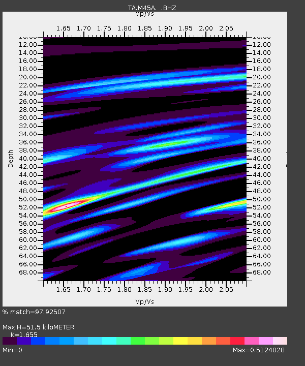
| Estimated Moho Depth: |
51.5 km |
| Estimated Crust Vp/Vs: |
1.65 |
| Assumed Crust Vp: |
6.498 km/s |
| Estimated Crust Vs: |
3.926 km/s |
| Estimated Crust Poisson's Ratio: |
0.21 |
|
| Radial Match: |
97.92507 % |
| Radial Bump: |
324 |
| Transverse Match: |
87.3272 % |
| Transverse Bump: |
400 |
| SOD ConfigId: |
488671 |
| Insert Time: |
2013-03-29 04:41:57.202 +0000 |
| GWidth: |
2.5 |
| Max Bumps: |
400 |
| Tol: |
0.001 |
|
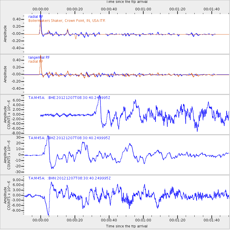
Signal To Noise
| Channel | StoN | STA | LTA |
| TA:M45A: :BHZ:20121207T08:30:40.249995Z | 68.508545 | 1.633906E-5 | 2.3849668E-7 |
| TA:M45A: :BHN:20121207T08:30:40.249995Z | 14.393487 | 5.178456E-6 | 3.5977772E-7 |
| TA:M45A: :BHE:20121207T08:30:40.249995Z | 15.034103 | 3.842971E-6 | 2.556169E-7 |
| Arrivals |
| Ps | 5.3 SECOND |
| PpPs | 21 SECOND |
| PsPs/PpSs | 26 SECOND |


