You are here: Home > Network List > TA - USArray Transportable Network (new EarthScope stations) Stations List
> Station L42A Oliver, Polo, IL, USA > Earthquake Result Viewer
L42A Oliver, Polo, IL, USA - Earthquake Result Viewer
| Earthquake location: |
Off East Coast Of Honshu, Japan |
| Earthquake latitude/longitude: |
37.9/143.9 |
| Earthquake time(UTC): |
2012/12/07 (342) 08:18:23 GMT |
| Earthquake Depth: |
31 km |
| Earthquake Magnitude: |
7.2 MB, 7.3 MS, 7.3 MW, 7.3 MW |
| Earthquake Catalog/Contributor: |
WHDF/NEIC |
|
| Network: |
TA USArray Transportable Network (new EarthScope stations) |
| Station: |
L42A Oliver, Polo, IL, USA |
| Lat/Lon: |
42.00 N/89.67 W |
| Elevation: |
257 m |
|
| Distance: |
86.7 deg |
| Az: |
36.945 deg |
| Baz: |
320.355 deg |
| Ray Param: |
0.043837626 |
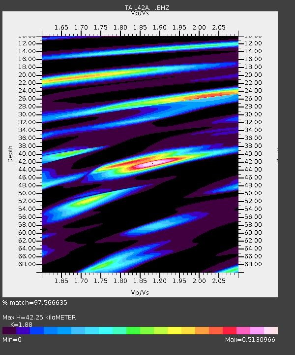
| Estimated Moho Depth: |
42.25 km |
| Estimated Crust Vp/Vs: |
1.88 |
| Assumed Crust Vp: |
6.571 km/s |
| Estimated Crust Vs: |
3.495 km/s |
| Estimated Crust Poisson's Ratio: |
0.30 |
|
| Radial Match: |
97.566635 % |
| Radial Bump: |
353 |
| Transverse Match: |
85.80118 % |
| Transverse Bump: |
400 |
| SOD ConfigId: |
488671 |
| Insert Time: |
2013-03-29 04:42:11.455 +0000 |
| GWidth: |
2.5 |
| Max Bumps: |
400 |
| Tol: |
0.001 |
|
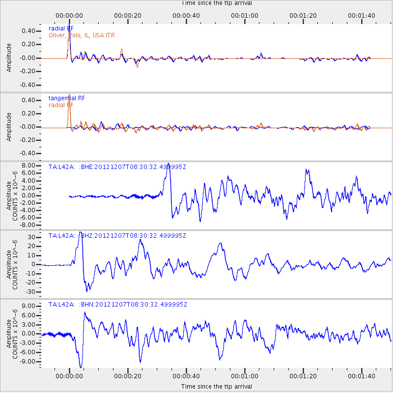
Signal To Noise
| Channel | StoN | STA | LTA |
| TA:L42A: :BHZ:20121207T08:30:32.499995Z | 50.371563 | 1.8817138E-5 | 3.7356668E-7 |
| TA:L42A: :BHN:20121207T08:30:32.499995Z | 19.10065 | 5.254984E-6 | 2.751207E-7 |
| TA:L42A: :BHE:20121207T08:30:32.499995Z | 24.188787 | 4.3675127E-6 | 1.8055938E-7 |
| Arrivals |
| Ps | 5.8 SECOND |
| PpPs | 18 SECOND |
| PsPs/PpSs | 24 SECOND |


