You are here: Home > Network List > TA - USArray Transportable Network (new EarthScope stations) Stations List
> Station P45A Graceland, Paris, IL, USA > Earthquake Result Viewer
P45A Graceland, Paris, IL, USA - Earthquake Result Viewer

| Earthquake location: |
Off East Coast Of Honshu, Japan |
| Earthquake latitude/longitude: |
37.9/143.9 |
| Earthquake time(UTC): |
2012/12/07 (342) 08:18:23 GMT |
| Earthquake Depth: |
31 km |
| Earthquake Magnitude: |
7.2 MB, 7.3 MS, 7.3 MW, 7.3 MW |
| Earthquake Catalog/Contributor: |
WHDF/NEIC |
|
| Network: |
TA USArray Transportable Network (new EarthScope stations) |
| Station: |
P45A Graceland, Paris, IL, USA |
| Lat/Lon: |
39.53 N/87.74 W |
| Elevation: |
193 m |
|
| Distance: |
89.5 deg |
| Az: |
37.367 deg |
| Baz: |
321.621 deg |
| Ray Param: |
0.041753188 |
| Estimated Moho Depth: |
47.5 km |
| Estimated Crust Vp/Vs: |
1.76 |
| Assumed Crust Vp: |
6.444 km/s |
| Estimated Crust Vs: |
3.667 km/s |
| Estimated Crust Poisson's Ratio: |
0.26 |
|
| Radial Match: |
97.57965 % |
| Radial Bump: |
274 |
| Transverse Match: |
87.23512 % |
| Transverse Bump: |
400 |
| SOD ConfigId: |
488671 |
| Insert Time: |
2013-03-29 04:42:31.448 +0000 |
| GWidth: |
2.5 |
| Max Bumps: |
400 |
| Tol: |
0.001 |
|
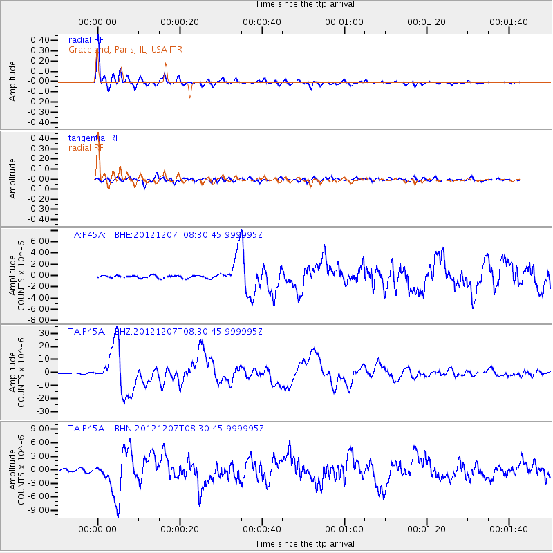
Signal To Noise
| Channel | StoN | STA | LTA |
| TA:P45A: :BHZ:20121207T08:30:45.999995Z | 63.058914 | 1.5716116E-5 | 2.492291E-7 |
| TA:P45A: :BHN:20121207T08:30:45.999995Z | 12.236911 | 3.7039765E-6 | 3.0268887E-7 |
| TA:P45A: :BHE:20121207T08:30:45.999995Z | 14.724573 | 3.0597994E-6 | 2.0780224E-7 |
| Arrivals |
| Ps | 5.7 SECOND |
| PpPs | 20 SECOND |
| PsPs/PpSs | 26 SECOND |


