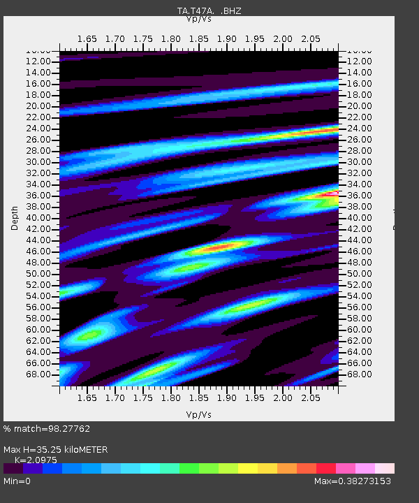
T47A Sharon Grove, KY, USA - Earthquake Result Viewer
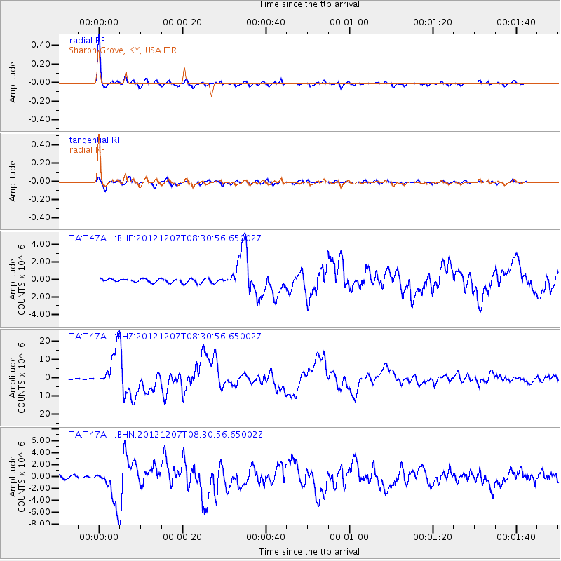
Earthquake location: Off East Coast Of Honshu, Japan
Earthquake latitude/longitude: 37.9/143.9
Earthquake time(UTC): 2012/12/07 (342) 08:18:23 GMT
Earthquake Depth: 31 km
Earthquake Magnitude: 7.2 MB, 7.3 MS, 7.3 MW, 7.3 MW
Earthquake Catalog/Contributor: WHDF/NEIC
Network: TA USArray Transportable Network (new EarthScope stations)
Station: T47A Sharon Grove, KY, USA
Lat/Lon: 36.99 N/87.11 W
Elevation: 217 m
Distance: 91.8 deg
Az: 38.539 deg
Baz: 322.001 deg
Ray Param: 0.041543614
Estimated Moho Depth: 35.25 km
Estimated Crust Vp/Vs: 2.10
Assumed Crust Vp: 6.444 km/s
Estimated Crust Vs: 3.072 km/s
Estimated Crust Poisson's Ratio: 0.35
Radial Match: 98.27762 %
Radial Bump: 263
Transverse Match: 93.47013 %
Transverse Bump: 400
SOD ConfigId: 488671
Insert Time: 2013-03-29 04:42:55.045 +0000
GWidth: 2.5
Max Bumps: 400
Tol: 0.001

Signal To Noise

ChannelStoNSTALTA
TA:T47A: :BHZ:20121207T08:30:56.65002Z37.0138471.0919308E-52.95006E-7
TA:T47A: :BHN:20121207T08:30:56.65002Z12.7504973.19847E-62.5085063E-7
TA:T47A: :BHE:20121207T08:30:56.65002Z9.8290122.0990506E-62.1355662E-7
Arrivals
Ps6.1 SECOND
PpPs17 SECOND
PsPs/PpSs23 SECOND