You are here: Home > Network List > TA - USArray Transportable Network (new EarthScope stations) Stations List
> Station R47A Wooly Knot Farm, English, IN, USA > Earthquake Result Viewer
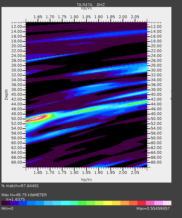
R47A Wooly Knot Farm, English, IN, USA - Earthquake Result Viewer
| Earthquake location: |
Off East Coast Of Honshu, Japan |
| Earthquake latitude/longitude: |
37.9/143.9 |
| Earthquake time(UTC): |
2012/12/07 (342) 08:18:23 GMT |
| Earthquake Depth: |
31 km |
| Earthquake Magnitude: |
7.2 MB, 7.3 MS, 7.3 MW, 7.3 MW |
| Earthquake Catalog/Contributor: |
WHDF/NEIC |
|
| Network: |
TA USArray Transportable Network (new EarthScope stations) |
| Station: |
R47A Wooly Knot Farm, English, IN, USA |
| Lat/Lon: |
38.30 N/86.53 W |
| Elevation: |
181 m |
|
| Distance: |
91.1 deg |
| Az: |
37.376 deg |
| Baz: |
322.382 deg |
| Ray Param: |
0.0416244 |
| Estimated Moho Depth: |
49.75 km |
| Estimated Crust Vp/Vs: |
1.64 |
| Assumed Crust Vp: |
6.444 km/s |
| Estimated Crust Vs: |
3.935 km/s |
| Estimated Crust Poisson's Ratio: |
0.20 |
|
| Radial Match: |
97.64481 % |
| Radial Bump: |
300 |
| Transverse Match: |
88.781105 % |
| Transverse Bump: |
400 |
| SOD ConfigId: |
488671 |
| Insert Time: |
2013-03-29 04:43:16.815 +0000 |
| GWidth: |
2.5 |
| Max Bumps: |
400 |
| Tol: |
0.001 |
|

Signal To Noise
| Channel | StoN | STA | LTA |
| TA:R47A: :BHZ:20121207T08:30:53.200007Z | 34.72389 | 1.23971495E-5 | 3.5702078E-7 |
| TA:R47A: :BHN:20121207T08:30:53.200007Z | 16.145298 | 3.1205318E-6 | 1.9327805E-7 |
| TA:R47A: :BHE:20121207T08:30:53.200007Z | 11.661322 | 2.414395E-6 | 2.0704302E-7 |
| Arrivals |
| Ps | 5.0 SECOND |
| PpPs | 20 SECOND |
| PsPs/PpSs | 25 SECOND |


