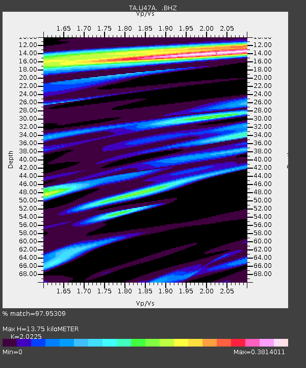
U47A Clarksville, TN, USA - Earthquake Result Viewer
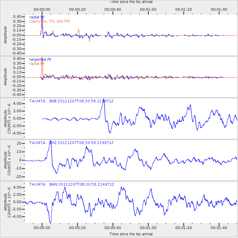
Earthquake location: Off East Coast Of Honshu, Japan
Earthquake latitude/longitude: 37.9/143.9
Earthquake time(UTC): 2012/12/07 (342) 08:18:23 GMT
Earthquake Depth: 31 km
Earthquake Magnitude: 7.2 MB, 7.3 MS, 7.3 MW, 7.3 MW
Earthquake Catalog/Contributor: WHDF/NEIC
Network: TA USArray Transportable Network (new EarthScope stations)
Station: U47A Clarksville, TN, USA
Lat/Lon: 36.44 N/87.29 W
Elevation: 145 m
Distance: 92.2 deg
Az: 38.992 deg
Baz: 321.876 deg
Ray Param: 0.041492283
Estimated Moho Depth: 13.75 km
Estimated Crust Vp/Vs: 2.02
Assumed Crust Vp: 6.444 km/s
Estimated Crust Vs: 3.186 km/s
Estimated Crust Poisson's Ratio: 0.34
Radial Match: 97.95309 %
Radial Bump: 400
Transverse Match: 93.98271 %
Transverse Bump: 400
SOD ConfigId: 488671
Insert Time: 2013-03-29 04:43:18.453 +0000
GWidth: 2.5
Max Bumps: 400
Tol: 0.001

Signal To Noise

ChannelStoNSTALTA
TA:U47A: :BHZ:20121207T08:30:58.224971Z42.5154469.981888E-62.3478263E-7
TA:U47A: :BHN:20121207T08:30:58.224971Z11.27664852.3198734E-62.0572367E-7
TA:U47A: :BHE:20121207T08:30:58.224971Z11.0866812.137383E-61.9278835E-7
Arrivals
Ps2.2 SECOND
PpPs6.3 SECOND
PsPs/PpSs8.6 SECOND