You are here: Home > Network List > TA - USArray Transportable Network (new EarthScope stations) Stations List
> Station U48A Cassie Pea, Portland, TN, USA > Earthquake Result Viewer
U48A Cassie Pea, Portland, TN, USA - Earthquake Result Viewer
| Earthquake location: |
Off East Coast Of Honshu, Japan |
| Earthquake latitude/longitude: |
37.9/143.9 |
| Earthquake time(UTC): |
2012/12/07 (342) 08:18:23 GMT |
| Earthquake Depth: |
31 km |
| Earthquake Magnitude: |
7.2 MB, 7.3 MS, 7.3 MW, 7.3 MW |
| Earthquake Catalog/Contributor: |
WHDF/NEIC |
|
| Network: |
TA USArray Transportable Network (new EarthScope stations) |
| Station: |
U48A Cassie Pea, Portland, TN, USA |
| Lat/Lon: |
36.51 N/86.54 W |
| Elevation: |
268 m |
|
| Distance: |
92.5 deg |
| Az: |
38.473 deg |
| Baz: |
322.34 deg |
| Ray Param: |
0.041440483 |
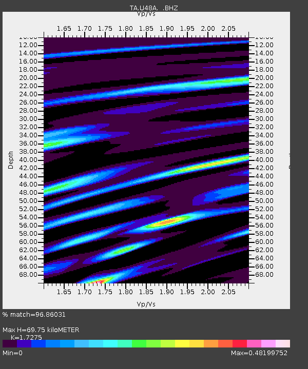
| Estimated Moho Depth: |
69.75 km |
| Estimated Crust Vp/Vs: |
1.73 |
| Assumed Crust Vp: |
6.444 km/s |
| Estimated Crust Vs: |
3.73 km/s |
| Estimated Crust Poisson's Ratio: |
0.25 |
|
| Radial Match: |
96.86031 % |
| Radial Bump: |
340 |
| Transverse Match: |
88.90868 % |
| Transverse Bump: |
400 |
| SOD ConfigId: |
488671 |
| Insert Time: |
2013-03-29 04:43:37.982 +0000 |
| GWidth: |
2.5 |
| Max Bumps: |
400 |
| Tol: |
0.001 |
|

Signal To Noise
| Channel | StoN | STA | LTA |
| TA:U48A: :BHZ:20121207T08:30:59.674983Z | 40.760273 | 9.457455E-6 | 2.320263E-7 |
| TA:U48A: :BHN:20121207T08:30:59.674983Z | 12.798965 | 2.3757407E-6 | 1.8561975E-7 |
| TA:U48A: :BHE:20121207T08:30:59.674983Z | 11.720834 | 1.9246813E-6 | 1.6421026E-7 |
| Arrivals |
| Ps | 8.0 SECOND |
| PpPs | 29 SECOND |
| PsPs/PpSs | 37 SECOND |


