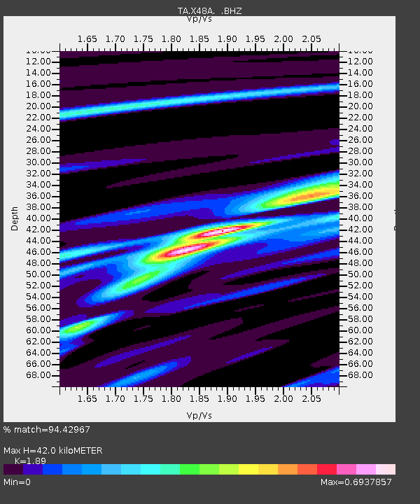
X48A Hartselle, AL, USA - Earthquake Result Viewer
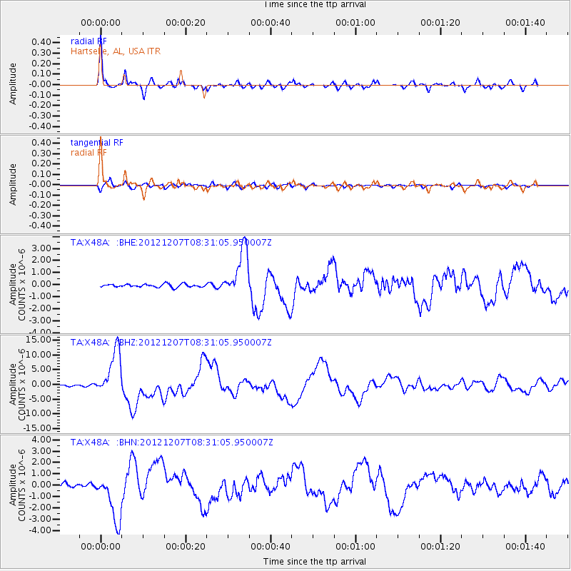
Earthquake location: Off East Coast Of Honshu, Japan
Earthquake latitude/longitude: 37.9/143.9
Earthquake time(UTC): 2012/12/07 (342) 08:18:23 GMT
Earthquake Depth: 31 km
Earthquake Magnitude: 7.2 MB, 7.3 MS, 7.3 MW, 7.3 MW
Earthquake Catalog/Contributor: WHDF/NEIC
Network: TA USArray Transportable Network (new EarthScope stations)
Station: X48A Hartselle, AL, USA
Lat/Lon: 34.45 N/87.05 W
Elevation: 180 m
Distance: 93.8 deg
Az: 40.061 deg
Baz: 321.96 deg
Ray Param: 0.041168213
Estimated Moho Depth: 42.0 km
Estimated Crust Vp/Vs: 1.89
Assumed Crust Vp: 6.476 km/s
Estimated Crust Vs: 3.426 km/s
Estimated Crust Poisson's Ratio: 0.31
Radial Match: 94.42967 %
Radial Bump: 386
Transverse Match: 85.72985 %
Transverse Bump: 400
SOD ConfigId: 488671
Insert Time: 2013-03-29 04:43:51.707 +0000
GWidth: 2.5
Max Bumps: 400
Tol: 0.001

Signal To Noise

ChannelStoNSTALTA
TA:X48A: :BHZ:20121207T08:31:05.950007Z35.384498.127391E-62.2968794E-7
TA:X48A: :BHN:20121207T08:31:05.950007Z11.617522.1842418E-61.8801273E-7
TA:X48A: :BHE:20121207T08:31:05.950007Z15.9962882.02704E-61.2671939E-7
Arrivals
Ps5.9 SECOND
PpPs18 SECOND
PsPs/PpSs24 SECOND