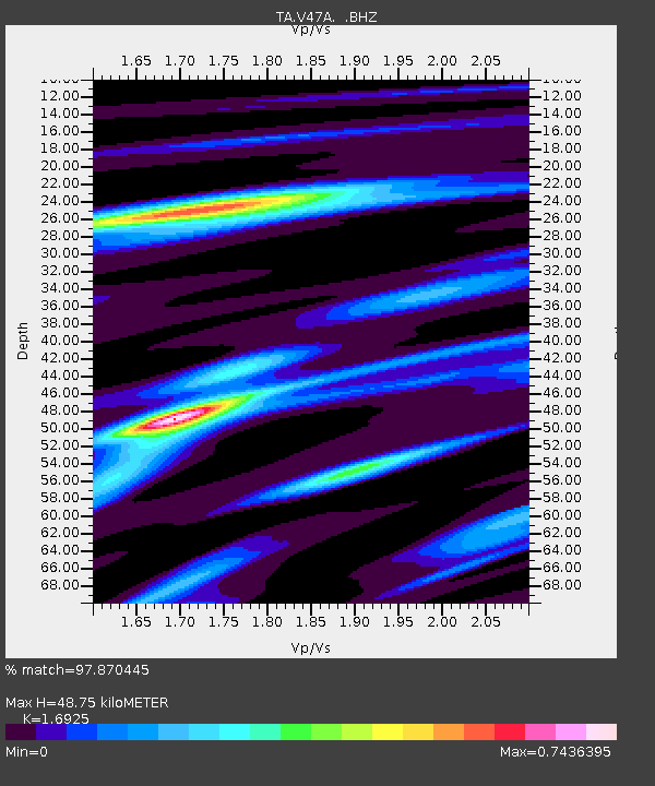
V47A Nunnelly, TN, USA - Earthquake Result Viewer

Earthquake location: Off East Coast Of Honshu, Japan
Earthquake latitude/longitude: 37.9/143.9
Earthquake time(UTC): 2012/12/07 (342) 08:18:23 GMT
Earthquake Depth: 31 km
Earthquake Magnitude: 7.2 MB, 7.3 MS, 7.3 MW, 7.3 MW
Earthquake Catalog/Contributor: WHDF/NEIC
Network: TA USArray Transportable Network (new EarthScope stations)
Station: V47A Nunnelly, TN, USA
Lat/Lon: 35.83 N/87.52 W
Elevation: 240 m
Distance: 92.5 deg
Az: 39.519 deg
Baz: 321.718 deg
Ray Param: 0.04143076
Estimated Moho Depth: 48.75 km
Estimated Crust Vp/Vs: 1.69
Assumed Crust Vp: 6.476 km/s
Estimated Crust Vs: 3.826 km/s
Estimated Crust Poisson's Ratio: 0.23
Radial Match: 97.870445 %
Radial Bump: 340
Transverse Match: 90.94921 %
Transverse Bump: 400
SOD ConfigId: 488671
Insert Time: 2013-03-29 04:44:34.182 +0000
GWidth: 2.5
Max Bumps: 400
Tol: 0.001

Signal To Noise

ChannelStoNSTALTA
TA:V47A: :BHZ:20121207T08:30:59.90002Z42.265991.0346695E-52.4479954E-7
TA:V47A: :BHN:20121207T08:30:59.90002Z19.3380812.8389416E-61.4680576E-7
TA:V47A: :BHE:20121207T08:30:59.90002Z10.1037712.3087957E-62.2850831E-7
Arrivals
Ps5.3 SECOND
PpPs20 SECOND
PsPs/PpSs25 SECOND