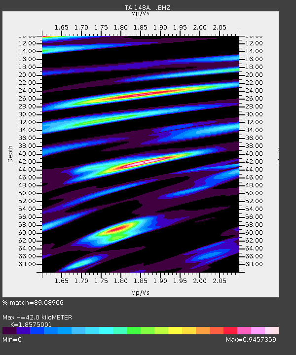
148A Greensboro, AL, USA - Earthquake Result Viewer

Earthquake location: Off East Coast Of Honshu, Japan
Earthquake latitude/longitude: 37.9/143.9
Earthquake time(UTC): 2012/12/07 (342) 08:18:23 GMT
Earthquake Depth: 31 km
Earthquake Magnitude: 7.2 MB, 7.3 MS, 7.3 MW, 7.3 MW
Earthquake Catalog/Contributor: WHDF/NEIC
Network: TA USArray Transportable Network (new EarthScope stations)
Station: 148A Greensboro, AL, USA
Lat/Lon: 32.65 N/87.57 W
Elevation: 63 m
Distance: 95.0 deg
Az: 41.525 deg
Baz: 321.558 deg
Ray Param: 0.040888105
Estimated Moho Depth: 42.0 km
Estimated Crust Vp/Vs: 1.86
Assumed Crust Vp: 6.565 km/s
Estimated Crust Vs: 3.534 km/s
Estimated Crust Poisson's Ratio: 0.30
Radial Match: 89.08906 %
Radial Bump: 400
Transverse Match: 73.45696 %
Transverse Bump: 400
SOD ConfigId: 488671
Insert Time: 2013-03-29 04:44:58.125 +0000
GWidth: 2.5
Max Bumps: 400
Tol: 0.001

Signal To Noise

ChannelStoNSTALTA
TA:148A: :BHZ:20121207T08:31:11.15002Z50.295988.618765E-61.7136091E-7
TA:148A: :BHN:20121207T08:31:11.15002Z4.73116452.264811E-64.7870054E-7
TA:148A: :BHE:20121207T08:31:11.15002Z3.64811971.7829477E-64.8873056E-7
Arrivals
Ps5.6 SECOND
PpPs18 SECOND
PsPs/PpSs24 SECOND