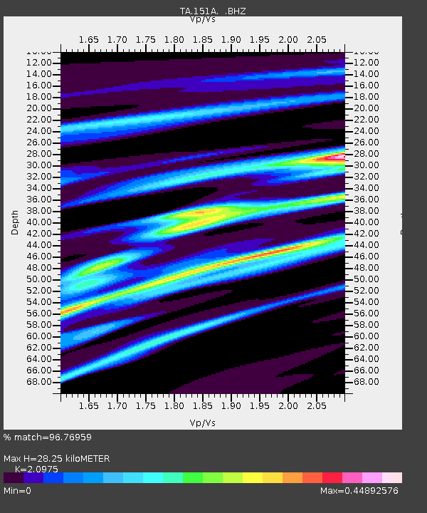
151A Opelika, AL, USA - Earthquake Result Viewer
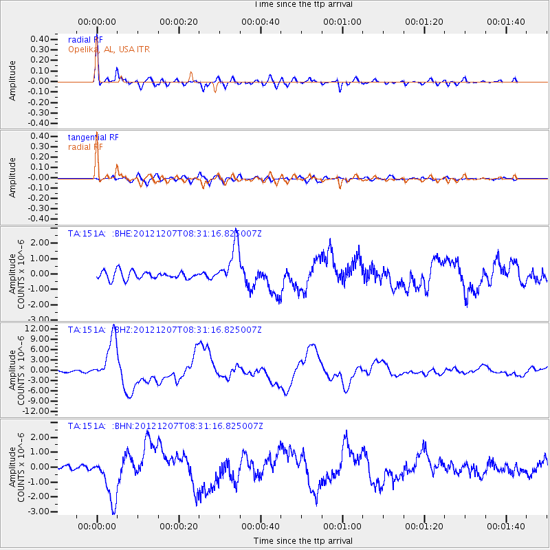
Earthquake location: Off East Coast Of Honshu, Japan
Earthquake latitude/longitude: 37.9/143.9
Earthquake time(UTC): 2012/12/07 (342) 08:18:23 GMT
Earthquake Depth: 31 km
Earthquake Magnitude: 7.2 MB, 7.3 MS, 7.3 MW, 7.3 MW
Earthquake Catalog/Contributor: WHDF/NEIC
Network: TA USArray Transportable Network (new EarthScope stations)
Station: 151A Opelika, AL, USA
Lat/Lon: 32.53 N/85.33 W
Elevation: 211 m
Distance: 96.2 deg
Az: 40.094 deg
Baz: 322.902 deg
Ray Param: 0.040554907
Estimated Moho Depth: 28.25 km
Estimated Crust Vp/Vs: 2.10
Assumed Crust Vp: 6.719 km/s
Estimated Crust Vs: 3.204 km/s
Estimated Crust Poisson's Ratio: 0.35
Radial Match: 96.76959 %
Radial Bump: 400
Transverse Match: 77.83332 %
Transverse Bump: 400
SOD ConfigId: 488671
Insert Time: 2013-03-29 04:45:22.113 +0000
GWidth: 2.5
Max Bumps: 400
Tol: 0.001

Signal To Noise

ChannelStoNSTALTA
TA:151A: :BHZ:20121207T08:31:16.825007Z19.9944276.5711656E-63.2864986E-7
TA:151A: :BHN:20121207T08:31:16.825007Z10.8306221.5741942E-61.4534662E-7
TA:151A: :BHE:20121207T08:31:16.825007Z5.26419731.3476142E-62.5599616E-7
Arrivals
Ps4.7 SECOND
PpPs13 SECOND
PsPs/PpSs17 SECOND