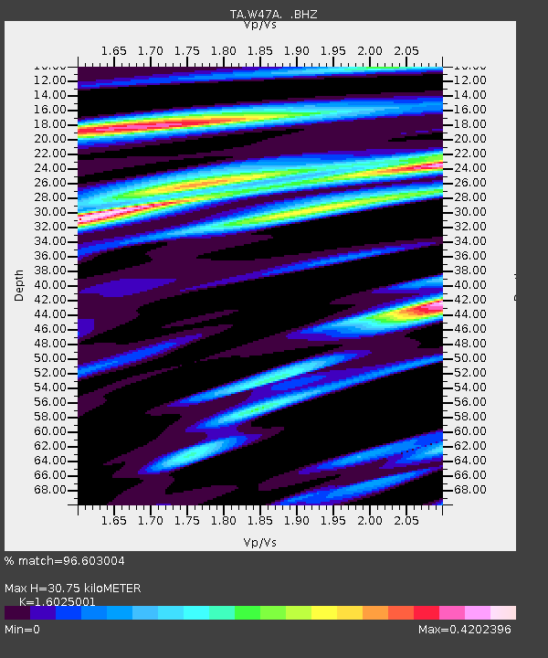
W47A Westpoint, TN, USA - Earthquake Result Viewer

Earthquake location: Off East Coast Of Honshu, Japan
Earthquake latitude/longitude: 37.9/143.9
Earthquake time(UTC): 2012/12/07 (342) 08:18:23 GMT
Earthquake Depth: 31 km
Earthquake Magnitude: 7.2 MB, 7.3 MS, 7.3 MW, 7.3 MW
Earthquake Catalog/Contributor: WHDF/NEIC
Network: TA USArray Transportable Network (new EarthScope stations)
Station: W47A Westpoint, TN, USA
Lat/Lon: 35.25 N/87.59 W
Elevation: 293 m
Distance: 92.9 deg
Az: 39.923 deg
Baz: 321.656 deg
Ray Param: 0.0413489
Estimated Moho Depth: 30.75 km
Estimated Crust Vp/Vs: 1.60
Assumed Crust Vp: 6.476 km/s
Estimated Crust Vs: 4.041 km/s
Estimated Crust Poisson's Ratio: 0.18
Radial Match: 96.603004 %
Radial Bump: 393
Transverse Match: 91.481476 %
Transverse Bump: 400
SOD ConfigId: 488671
Insert Time: 2013-03-29 04:45:45.377 +0000
GWidth: 2.5
Max Bumps: 400
Tol: 0.001

Signal To Noise

ChannelStoNSTALTA
TA:W47A: :BHZ:20121207T08:31:01.799983Z49.7168271.0021172E-52.01565E-7
TA:W47A: :BHN:20121207T08:31:01.799983Z15.0792122.5305799E-61.6781911E-7
TA:W47A: :BHE:20121207T08:31:01.799983Z11.9855662.0807277E-61.7360279E-7
Arrivals
Ps2.9 SECOND
PpPs12 SECOND
PsPs/PpSs15 SECOND