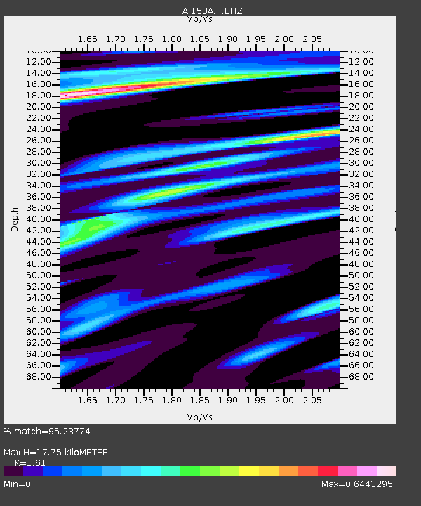
153A Fort Valley, GA, USA - Earthquake Result Viewer
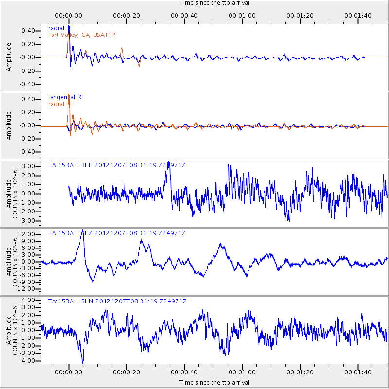
Earthquake location: Off East Coast Of Honshu, Japan
Earthquake latitude/longitude: 37.9/143.9
Earthquake time(UTC): 2012/12/07 (342) 08:18:23 GMT
Earthquake Depth: 31 km
Earthquake Magnitude: 7.2 MB, 7.3 MS, 7.3 MW, 7.3 MW
Earthquake Catalog/Contributor: WHDF/NEIC
Network: TA USArray Transportable Network (new EarthScope stations)
Station: 153A Fort Valley, GA, USA
Lat/Lon: 32.66 N/83.83 W
Elevation: 160 m
Distance: 96.9 deg
Az: 38.994 deg
Baz: 323.829 deg
Ray Param: 0.04036418
Estimated Moho Depth: 17.75 km
Estimated Crust Vp/Vs: 1.61
Assumed Crust Vp: 6.565 km/s
Estimated Crust Vs: 4.077 km/s
Estimated Crust Poisson's Ratio: 0.19
Radial Match: 95.23774 %
Radial Bump: 400
Transverse Match: 68.58401 %
Transverse Bump: 400
SOD ConfigId: 488671
Insert Time: 2013-03-29 04:46:34.031 +0000
GWidth: 2.5
Max Bumps: 400
Tol: 0.001

Signal To Noise

ChannelStoNSTALTA
TA:153A: :BHZ:20121207T08:31:19.724971Z13.3467586.0070197E-64.5007334E-7
TA:153A: :BHN:20121207T08:31:19.724971Z4.48792271.5709799E-63.5004612E-7
TA:153A: :BHE:20121207T08:31:19.724971Z3.33607721.477495E-64.4288393E-7
Arrivals
Ps1.7 SECOND
PpPs6.9 SECOND
PsPs/PpSs8.6 SECOND