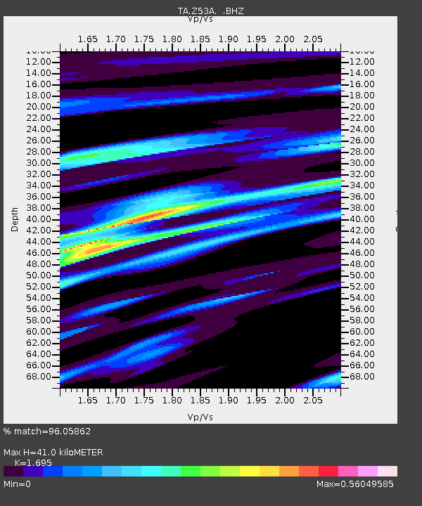
Z53A Monticello, GA, USA - Earthquake Result Viewer

Earthquake location: Off East Coast Of Honshu, Japan
Earthquake latitude/longitude: 37.9/143.9
Earthquake time(UTC): 2012/12/07 (342) 08:18:23 GMT
Earthquake Depth: 31 km
Earthquake Magnitude: 7.2 MB, 7.3 MS, 7.3 MW, 7.3 MW
Earthquake Catalog/Contributor: WHDF/NEIC
Network: TA USArray Transportable Network (new EarthScope stations)
Station: Z53A Monticello, GA, USA
Lat/Lon: 33.28 N/83.57 W
Elevation: 144 m
Distance: 96.5 deg
Az: 38.45 deg
Baz: 324.034 deg
Ray Param: 0.04047606
Estimated Moho Depth: 41.0 km
Estimated Crust Vp/Vs: 1.70
Assumed Crust Vp: 6.565 km/s
Estimated Crust Vs: 3.873 km/s
Estimated Crust Poisson's Ratio: 0.23
Radial Match: 96.05862 %
Radial Bump: 400
Transverse Match: 79.36786 %
Transverse Bump: 400
SOD ConfigId: 488671
Insert Time: 2013-03-29 04:47:40.988 +0000
GWidth: 2.5
Max Bumps: 400
Tol: 0.001

Signal To Noise

ChannelStoNSTALTA
TA:Z53A: :BHZ:20121207T08:31:18.049983Z26.4397646.0794814E-62.2993704E-7
TA:Z53A: :BHN:20121207T08:31:18.049983Z5.5487631.609688E-62.9009854E-7
TA:Z53A: :BHE:20121207T08:31:18.049983Z6.15263941.1471808E-61.8645343E-7
Arrivals
Ps4.4 SECOND
PpPs16 SECOND
PsPs/PpSs21 SECOND