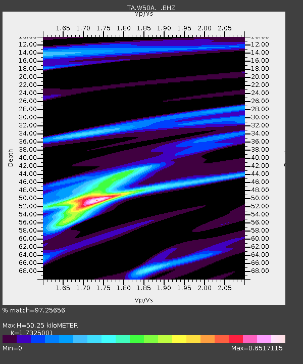
W50A Signal Mountain, TN, USA - Earthquake Result Viewer

Earthquake location: Off East Coast Of Honshu, Japan
Earthquake latitude/longitude: 37.9/143.9
Earthquake time(UTC): 2012/12/07 (342) 08:18:23 GMT
Earthquake Depth: 31 km
Earthquake Magnitude: 7.2 MB, 7.3 MS, 7.3 MW, 7.3 MW
Earthquake Catalog/Contributor: WHDF/NEIC
Network: TA USArray Transportable Network (new EarthScope stations)
Station: W50A Signal Mountain, TN, USA
Lat/Lon: 35.20 N/85.31 W
Elevation: 587 m
Distance: 94.1 deg
Az: 38.472 deg
Baz: 323.056 deg
Ray Param: 0.041105438
Estimated Moho Depth: 50.25 km
Estimated Crust Vp/Vs: 1.73
Assumed Crust Vp: 6.35 km/s
Estimated Crust Vs: 3.665 km/s
Estimated Crust Poisson's Ratio: 0.25
Radial Match: 97.25656 %
Radial Bump: 271
Transverse Match: 85.57074 %
Transverse Bump: 400
SOD ConfigId: 488671
Insert Time: 2013-03-29 04:48:25.737 +0000
GWidth: 2.5
Max Bumps: 400
Tol: 0.001

Signal To Noise

ChannelStoNSTALTA
TA:W50A: :BHZ:20121207T08:31:07.200007Z19.4735348.875883E-64.557921E-7
TA:W50A: :BHN:20121207T08:31:07.200007Z9.5560012.2983652E-62.405154E-7
TA:W50A: :BHE:20121207T08:31:07.200007Z7.1104741.9564766E-62.7515415E-7
Arrivals
Ps5.9 SECOND
PpPs21 SECOND
PsPs/PpSs27 SECOND