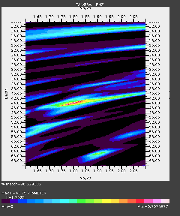
V53A Saluda, NC, USA - Earthquake Result Viewer
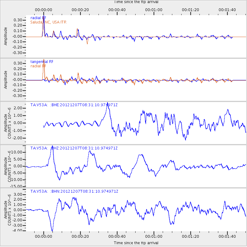
Earthquake location: Off East Coast Of Honshu, Japan
Earthquake latitude/longitude: 37.9/143.9
Earthquake time(UTC): 2012/12/07 (342) 08:18:23 GMT
Earthquake Depth: 31 km
Earthquake Magnitude: 7.2 MB, 7.3 MS, 7.3 MW, 7.3 MW
Earthquake Catalog/Contributor: WHDF/NEIC
Network: TA USArray Transportable Network (new EarthScope stations)
Station: V53A Saluda, NC, USA
Lat/Lon: 35.67 N/82.81 W
Elevation: 681 m
Distance: 94.9 deg
Az: 36.541 deg
Baz: 324.652 deg
Ray Param: 0.040898874
Estimated Moho Depth: 43.75 km
Estimated Crust Vp/Vs: 1.79
Assumed Crust Vp: 6.35 km/s
Estimated Crust Vs: 3.543 km/s
Estimated Crust Poisson's Ratio: 0.27
Radial Match: 96.529335 %
Radial Bump: 400
Transverse Match: 87.03496 %
Transverse Bump: 400
SOD ConfigId: 488671
Insert Time: 2013-03-29 04:49:02.424 +0000
GWidth: 2.5
Max Bumps: 400
Tol: 0.001

Signal To Noise

ChannelStoNSTALTA
TA:V53A: :BHZ:20121207T08:31:10.974971Z18.407226.639642E-63.6070855E-7
TA:V53A: :BHN:20121207T08:31:10.974971Z6.48745351.6762922E-62.5838986E-7
TA:V53A: :BHE:20121207T08:31:10.974971Z6.020711.1161148E-61.8537928E-7
Arrivals
Ps5.6 SECOND
PpPs19 SECOND
PsPs/PpSs24 SECOND