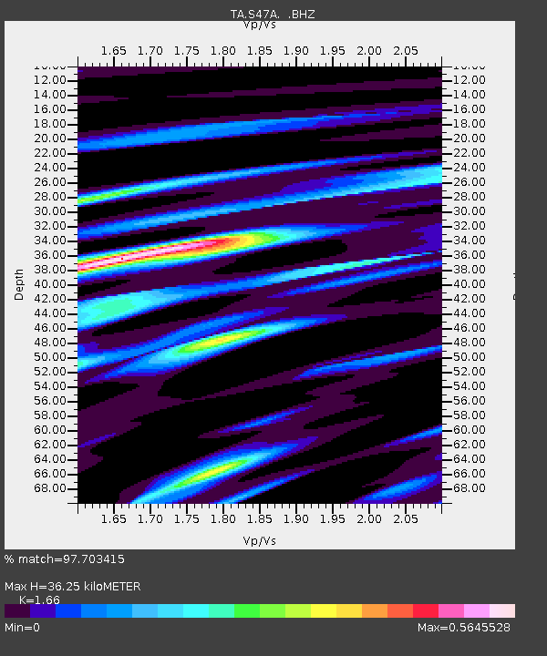
S47A Hartford, KY, USA - Earthquake Result Viewer
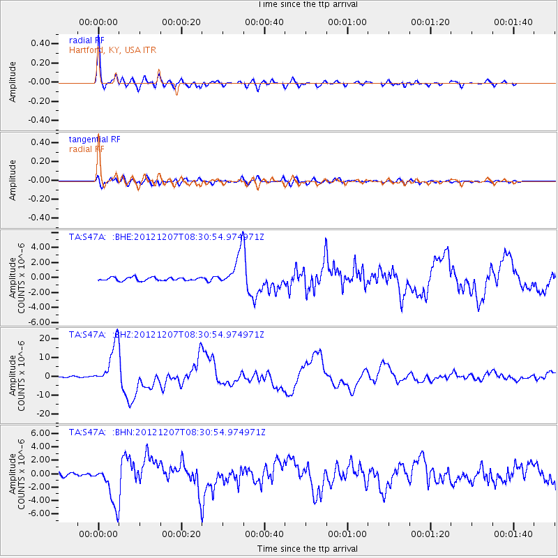
Earthquake location: Off East Coast Of Honshu, Japan
Earthquake latitude/longitude: 37.9/143.9
Earthquake time(UTC): 2012/12/07 (342) 08:18:23 GMT
Earthquake Depth: 31 km
Earthquake Magnitude: 7.2 MB, 7.3 MS, 7.3 MW, 7.3 MW
Earthquake Catalog/Contributor: WHDF/NEIC
Network: TA USArray Transportable Network (new EarthScope stations)
Station: S47A Hartford, KY, USA
Lat/Lon: 37.59 N/86.88 W
Elevation: 181 m
Distance: 91.5 deg
Az: 38.024 deg
Baz: 322.153 deg
Ray Param: 0.04159703
Estimated Moho Depth: 36.25 km
Estimated Crust Vp/Vs: 1.66
Assumed Crust Vp: 6.444 km/s
Estimated Crust Vs: 3.882 km/s
Estimated Crust Poisson's Ratio: 0.22
Radial Match: 97.703415 %
Radial Bump: 400
Transverse Match: 90.06808 %
Transverse Bump: 400
SOD ConfigId: 488671
Insert Time: 2013-03-29 04:49:59.369 +0000
GWidth: 2.5
Max Bumps: 400
Tol: 0.001

Signal To Noise

ChannelStoNSTALTA
TA:S47A: :BHZ:20121207T08:30:54.974971Z39.9925271.1542373E-52.8861325E-7
TA:S47A: :BHN:20121207T08:30:54.974971Z14.3466583.1180741E-62.1733803E-7
TA:S47A: :BHE:20121207T08:30:54.974971Z11.3794422.4223089E-62.1286709E-7
Arrivals
Ps3.8 SECOND
PpPs15 SECOND
PsPs/PpSs18 SECOND