You are here: Home > Network List > TA - USArray Transportable Network (new EarthScope stations) Stations List
> Station TFRD Ford Ranch, Anza, CA, USA > Earthquake Result Viewer
TFRD Ford Ranch, Anza, CA, USA - Earthquake Result Viewer
| Earthquake location: |
Off East Coast Of Honshu, Japan |
| Earthquake latitude/longitude: |
37.9/143.9 |
| Earthquake time(UTC): |
2012/12/07 (342) 08:18:23 GMT |
| Earthquake Depth: |
31 km |
| Earthquake Magnitude: |
7.2 MB, 7.3 MS, 7.3 MW, 7.3 MW |
| Earthquake Catalog/Contributor: |
WHDF/NEIC |
|
| Network: |
TA USArray Transportable Network (new EarthScope stations) |
| Station: |
TFRD Ford Ranch, Anza, CA, USA |
| Lat/Lon: |
33.49 N/116.60 W |
| Elevation: |
1000 m |
|
| Distance: |
76.9 deg |
| Az: |
57.83 deg |
| Baz: |
306.732 deg |
| Ray Param: |
0.05067115 |
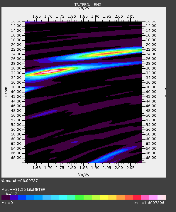
| Estimated Moho Depth: |
31.25 km |
| Estimated Crust Vp/Vs: |
1.70 |
| Assumed Crust Vp: |
6.264 km/s |
| Estimated Crust Vs: |
3.684 km/s |
| Estimated Crust Poisson's Ratio: |
0.24 |
|
| Radial Match: |
96.90737 % |
| Radial Bump: |
350 |
| Transverse Match: |
90.23518 % |
| Transverse Bump: |
400 |
| SOD ConfigId: |
488671 |
| Insert Time: |
2013-03-29 04:50:34.154 +0000 |
| GWidth: |
2.5 |
| Max Bumps: |
400 |
| Tol: |
0.001 |
|
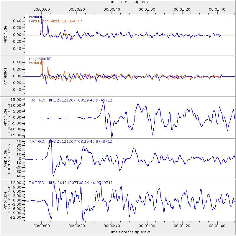
Signal To Noise
| Channel | StoN | STA | LTA |
| TA:TFRD: :BHZ:20121207T08:29:40.974971Z | 62.901928 | 1.491946E-5 | 2.3718606E-7 |
| TA:TFRD: :BHN:20121207T08:29:40.974971Z | 23.741001 | 3.936068E-6 | 1.65792E-7 |
| TA:TFRD: :BHE:20121207T08:29:40.974971Z | 18.336138 | 4.0124783E-6 | 2.1882899E-7 |
| Arrivals |
| Ps | 3.6 SECOND |
| PpPs | 13 SECOND |
| PsPs/PpSs | 17 SECOND |


