You are here: Home > Network List > TA - USArray Transportable Network (new EarthScope stations) Stations List
> Station 121A Cookes Peak, Deming, NM, USA > Earthquake Result Viewer
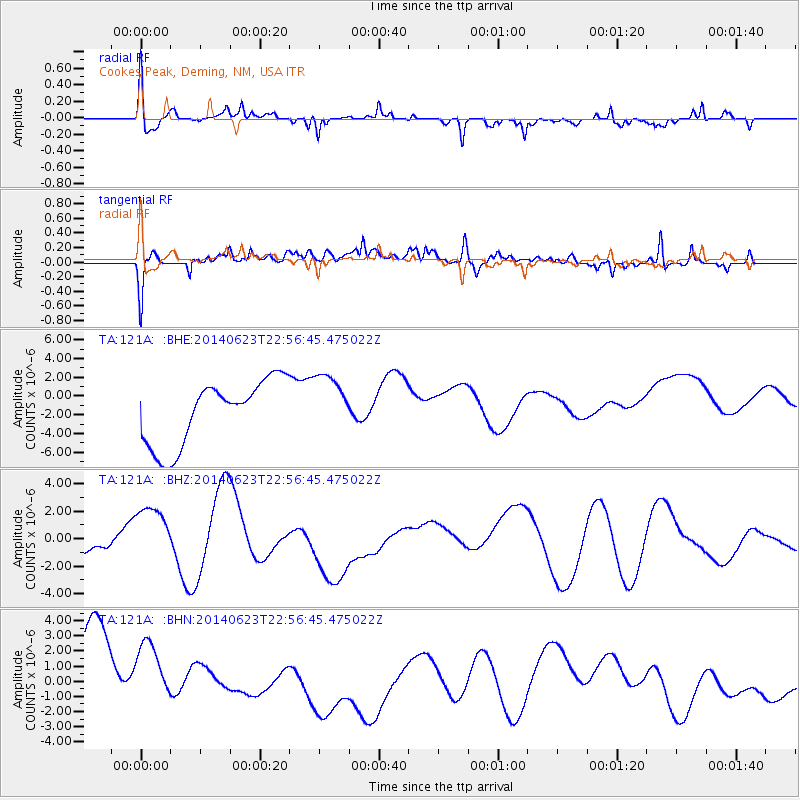
121A Cookes Peak, Deming, NM, USA - Earthquake Result Viewer
*The percent match for this event was below the threshold and hence no stack was calculated.
| Earthquake location: |
Rat Islands, Aleutian Islands |
| Earthquake latitude/longitude: |
52.0/178.4 |
| Earthquake time(UTC): |
2014/06/23 (174) 22:47:53 GMT |
| Earthquake Depth: |
116 km |
| Earthquake Magnitude: |
4.8 mb |
| Earthquake Catalog/Contributor: |
ISC/ISC |
|
| Network: |
TA USArray Transportable Network (new EarthScope stations) |
| Station: |
121A Cookes Peak, Deming, NM, USA |
| Lat/Lon: |
32.53 N/107.79 W |
| Elevation: |
1652 m |
|
| Distance: |
55.5 deg |
| Az: |
79.824 deg |
| Baz: |
313.942 deg |
| Ray Param: |
$rayparam |
*The percent match for this event was below the threshold and hence was not used in the summary stack. |
|
| Radial Match: |
55.378967 % |
| Radial Bump: |
400 |
| Transverse Match: |
37.915844 % |
| Transverse Bump: |
400 |
| SOD ConfigId: |
3390531 |
| Insert Time: |
2019-04-12 11:48:41.308 +0000 |
| GWidth: |
2.5 |
| Max Bumps: |
400 |
| Tol: |
0.001 |
|
Signal To Noise
| Channel | StoN | STA | LTA |
| TA:121A: :BHZ:20140623T22:56:45.475022Z | 2.517115 | 2.2164818E-6 | 8.805644E-7 |
| TA:121A: :BHN:20140623T22:56:45.475022Z | 0.996694 | 2.3498983E-6 | 2.357693E-6 |
| TA:121A: :BHE:20140623T22:56:45.475022Z | 0.9571294 | 3.279442E-6 | 3.4263307E-6 |
| Arrivals |
| Ps | |
| PpPs | |
| PsPs/PpSs | |


