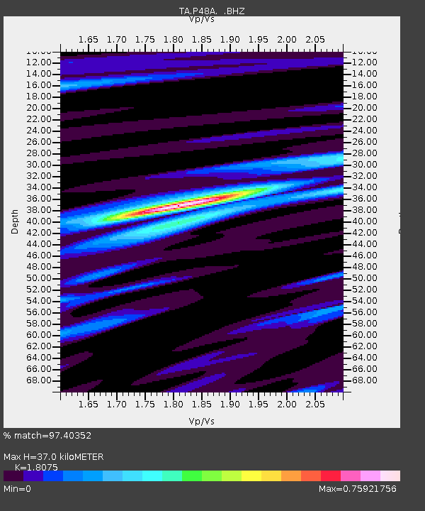
P48A Milroy, IN, USA - Earthquake Result Viewer

Earthquake location: Off East Coast Of Honshu, Japan
Earthquake latitude/longitude: 37.9/143.9
Earthquake time(UTC): 2012/12/07 (342) 08:18:23 GMT
Earthquake Depth: 31 km
Earthquake Magnitude: 7.2 MB, 7.3 MS, 7.3 MW, 7.3 MW
Earthquake Catalog/Contributor: WHDF/NEIC
Network: TA USArray Transportable Network (new EarthScope stations)
Station: P48A Milroy, IN, USA
Lat/Lon: 39.46 N/85.43 W
Elevation: 300 m
Distance: 90.7 deg
Az: 35.988 deg
Baz: 323.092 deg
Ray Param: 0.0416533
Estimated Moho Depth: 37.0 km
Estimated Crust Vp/Vs: 1.81
Assumed Crust Vp: 6.498 km/s
Estimated Crust Vs: 3.595 km/s
Estimated Crust Poisson's Ratio: 0.28
Radial Match: 97.40352 %
Radial Bump: 290
Transverse Match: 87.45553 %
Transverse Bump: 400
SOD ConfigId: 488671
Insert Time: 2013-03-29 04:51:12.615 +0000
GWidth: 2.5
Max Bumps: 400
Tol: 0.001

Signal To Noise

ChannelStoNSTALTA
TA:P48A: :BHZ:20121207T08:30:51.325007Z35.3897441.43993575E-54.0687937E-7
TA:P48A: :BHN:20121207T08:30:51.325007Z11.6122843.8097799E-63.2808188E-7
TA:P48A: :BHE:20121207T08:30:51.325007Z10.1963213.2481023E-63.1855632E-7
Arrivals
Ps4.7 SECOND
PpPs16 SECOND
PsPs/PpSs20 SECOND