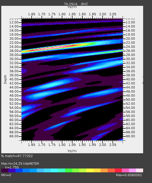
Q51A Peebles, OH, USA - Earthquake Result Viewer
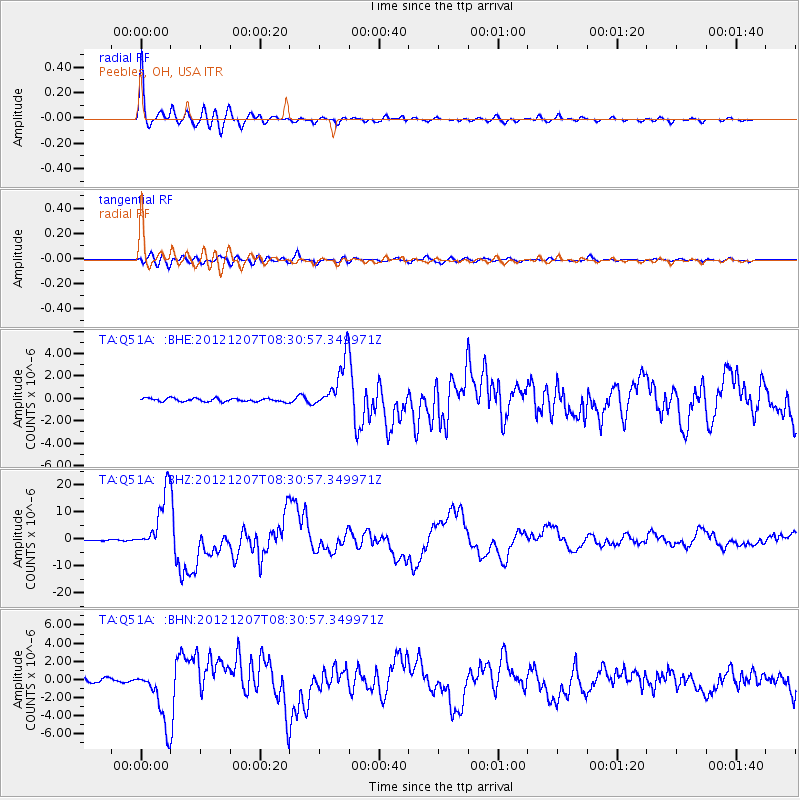
Earthquake location: Off East Coast Of Honshu, Japan
Earthquake latitude/longitude: 37.9/143.9
Earthquake time(UTC): 2012/12/07 (342) 08:18:23 GMT
Earthquake Depth: 31 km
Earthquake Magnitude: 7.2 MB, 7.3 MS, 7.3 MW, 7.3 MW
Earthquake Catalog/Contributor: WHDF/NEIC
Network: TA USArray Transportable Network (new EarthScope stations)
Station: Q51A Peebles, OH, USA
Lat/Lon: 39.03 N/83.35 W
Elevation: 362 m
Distance: 92.0 deg
Az: 34.941 deg
Baz: 324.426 deg
Ray Param: 0.041520897
Estimated Moho Depth: 24.25 km
Estimated Crust Vp/Vs: 1.75
Assumed Crust Vp: 6.232 km/s
Estimated Crust Vs: 3.551 km/s
Estimated Crust Poisson's Ratio: 0.26
Radial Match: 97.77202 %
Radial Bump: 392
Transverse Match: 88.901924 %
Transverse Bump: 400
SOD ConfigId: 488671
Insert Time: 2013-03-29 04:51:15.957 +0000
GWidth: 2.5
Max Bumps: 400
Tol: 0.001

Signal To Noise

ChannelStoNSTALTA
TA:Q51A: :BHZ:20121207T08:30:57.349971Z86.3607251.0819904E-51.2528731E-7
TA:Q51A: :BHN:20121207T08:30:57.349971Z11.4531363.1038119E-62.7100103E-7
TA:Q51A: :BHE:20121207T08:30:57.349971Z14.8727082.2431639E-61.5082416E-7
Arrivals
Ps3.0 SECOND
PpPs11 SECOND
PsPs/PpSs14 SECOND