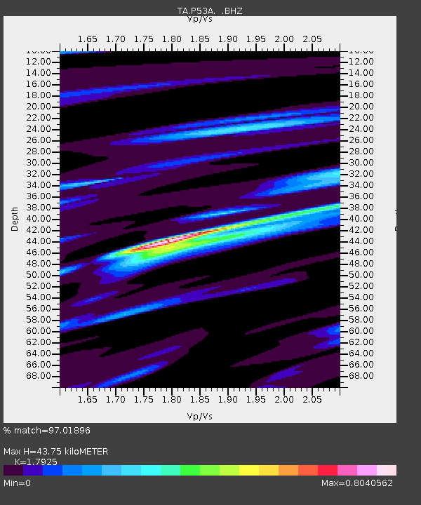
P53A Whipple, OH, USA - Earthquake Result Viewer

Earthquake location: Off East Coast Of Honshu, Japan
Earthquake latitude/longitude: 37.9/143.9
Earthquake time(UTC): 2012/12/07 (342) 08:18:23 GMT
Earthquake Depth: 31 km
Earthquake Magnitude: 7.2 MB, 7.3 MS, 7.3 MW, 7.3 MW
Earthquake Catalog/Contributor: WHDF/NEIC
Network: TA USArray Transportable Network (new EarthScope stations)
Station: P53A Whipple, OH, USA
Lat/Lon: 39.49 N/81.39 W
Elevation: 270 m
Distance: 92.5 deg
Az: 33.431 deg
Baz: 325.718 deg
Ray Param: 0.041442987
Estimated Moho Depth: 43.75 km
Estimated Crust Vp/Vs: 1.79
Assumed Crust Vp: 6.207 km/s
Estimated Crust Vs: 3.463 km/s
Estimated Crust Poisson's Ratio: 0.27
Radial Match: 97.01896 %
Radial Bump: 336
Transverse Match: 88.81273 %
Transverse Bump: 400
SOD ConfigId: 488671
Insert Time: 2013-03-29 04:52:20.439 +0000
GWidth: 2.5
Max Bumps: 400
Tol: 0.001

Signal To Noise

ChannelStoNSTALTA
TA:P53A: :BHZ:20121207T08:30:59.624995Z27.5216731.04312985E-53.7902123E-7
TA:P53A: :BHN:20121207T08:30:59.624995Z10.92141152.809519E-62.572487E-7
TA:P53A: :BHE:20121207T08:30:59.624995Z11.0456692.308134E-62.0896282E-7
Arrivals
Ps5.7 SECOND
PpPs19 SECOND
PsPs/PpSs25 SECOND