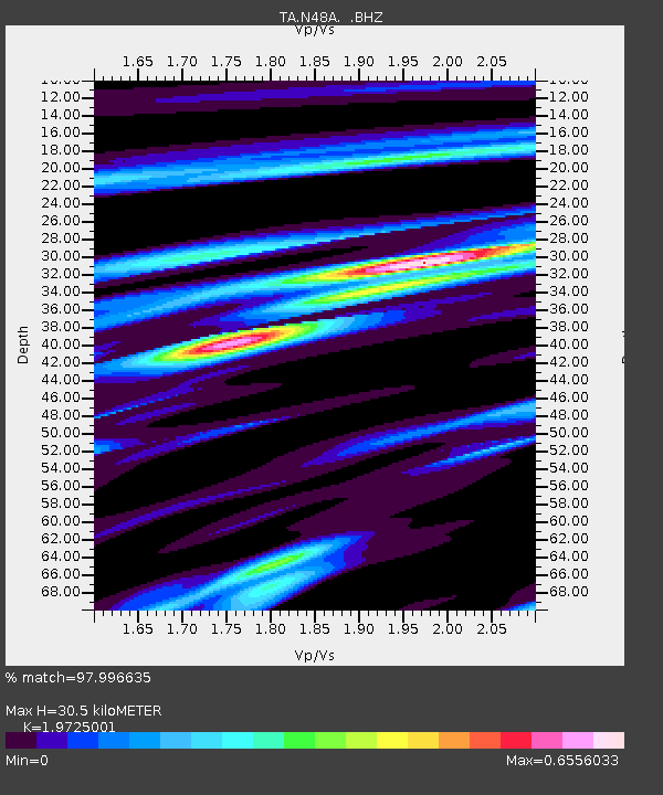
N48A Decatur, IN, USA - Earthquake Result Viewer
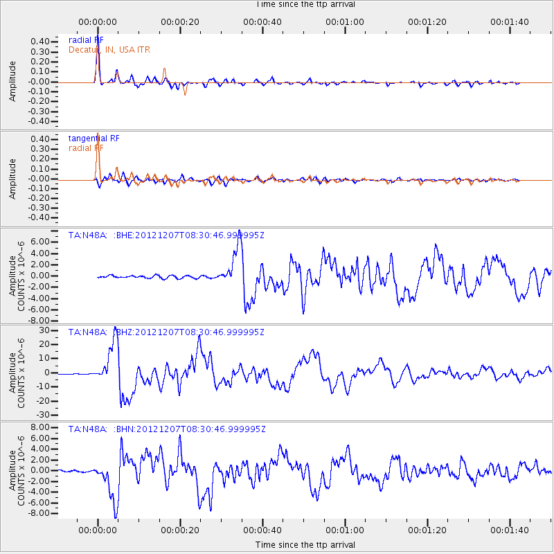
Earthquake location: Off East Coast Of Honshu, Japan
Earthquake latitude/longitude: 37.9/143.9
Earthquake time(UTC): 2012/12/07 (342) 08:18:23 GMT
Earthquake Depth: 31 km
Earthquake Magnitude: 7.2 MB, 7.3 MS, 7.3 MW, 7.3 MW
Earthquake Catalog/Contributor: WHDF/NEIC
Network: TA USArray Transportable Network (new EarthScope stations)
Station: N48A Decatur, IN, USA
Lat/Lon: 40.86 N/85.03 W
Elevation: 250 m
Distance: 89.7 deg
Az: 34.906 deg
Baz: 323.351 deg
Ray Param: 0.041720055
Estimated Moho Depth: 30.5 km
Estimated Crust Vp/Vs: 1.97
Assumed Crust Vp: 6.498 km/s
Estimated Crust Vs: 3.294 km/s
Estimated Crust Poisson's Ratio: 0.33
Radial Match: 97.996635 %
Radial Bump: 319
Transverse Match: 95.68019 %
Transverse Bump: 400
SOD ConfigId: 488671
Insert Time: 2013-03-29 04:52:31.615 +0000
GWidth: 2.5
Max Bumps: 400
Tol: 0.001

Signal To Noise

ChannelStoNSTALTA
TA:N48A: :BHZ:20121207T08:30:46.999995Z52.32591.570242E-53.0008886E-7
TA:N48A: :BHN:20121207T08:30:46.999995Z15.3765173.953645E-62.5712225E-7
TA:N48A: :BHE:20121207T08:30:46.999995Z15.8082223.5883081E-62.2698998E-7
Arrivals
Ps4.7 SECOND
PpPs14 SECOND
PsPs/PpSs18 SECOND