L46A Eue Claire, MI, USA - Earthquake Result Viewer
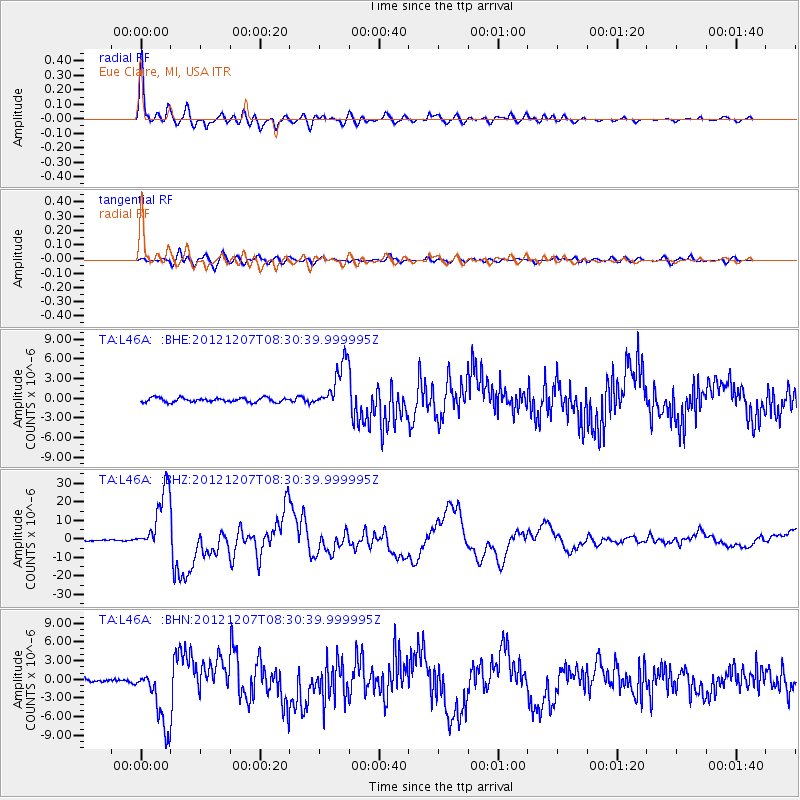
Earthquake location: Off East Coast Of Honshu, Japan
Earthquake latitude/longitude: 37.9/143.9
Earthquake time(UTC): 2012/12/07 (342) 08:18:23 GMT
Earthquake Depth: 31 km
Earthquake Magnitude: 7.2 MB, 7.3 MS, 7.3 MW, 7.3 MW
Earthquake Catalog/Contributor: WHDF/NEIC
Network: TA USArray Transportable Network (new EarthScope stations)
Station: L46A Eue Claire, MI, USA
Lat/Lon: 42.01 N/86.30 W
Elevation: 223 m
Distance: 88.2 deg
Az: 34.973 deg
Baz: 322.516 deg
Ray Param: 0.042696416
Estimated Moho Depth: 36.75 km
Estimated Crust Vp/Vs: 1.80
Assumed Crust Vp: 6.483 km/s
Estimated Crust Vs: 3.596 km/s
Estimated Crust Poisson's Ratio: 0.28
Radial Match: 97.606804 %
Radial Bump: 400
Transverse Match: 85.33104 %
Transverse Bump: 400
SOD ConfigId: 488671
Insert Time: 2013-03-29 04:53:11.151 +0000
GWidth: 2.5
Max Bumps: 400
Tol: 0.001

Signal To Noise

ChannelStoNSTALTA
TA:L46A: :BHZ:20121207T08:30:39.999995Z47.580581.7106722E-53.595316E-7
TA:L46A: :BHN:20121207T08:30:39.999995Z14.6936774.807986E-63.2721462E-7
TA:L46A: :BHE:20121207T08:30:39.999995Z10.8507323.5873084E-63.3060522E-7
Arrivals
Ps4.6 SECOND
PpPs16 SECOND
PsPs/PpSs20 SECOND