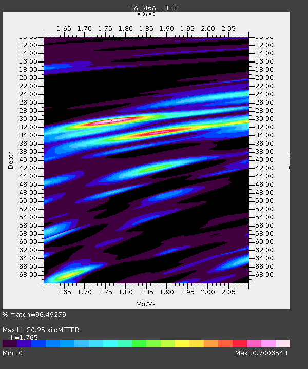
K46A Dorr, MI, USA - Earthquake Result Viewer

Earthquake location: Off East Coast Of Honshu, Japan
Earthquake latitude/longitude: 37.9/143.9
Earthquake time(UTC): 2012/12/07 (342) 08:18:23 GMT
Earthquake Depth: 31 km
Earthquake Magnitude: 7.2 MB, 7.3 MS, 7.3 MW, 7.3 MW
Earthquake Catalog/Contributor: WHDF/NEIC
Network: TA USArray Transportable Network (new EarthScope stations)
Station: K46A Dorr, MI, USA
Lat/Lon: 42.69 N/85.78 W
Elevation: 213 m
Distance: 87.9 deg
Az: 34.262 deg
Baz: 322.836 deg
Ray Param: 0.04292309
Estimated Moho Depth: 30.25 km
Estimated Crust Vp/Vs: 1.76
Assumed Crust Vp: 6.483 km/s
Estimated Crust Vs: 3.673 km/s
Estimated Crust Poisson's Ratio: 0.26
Radial Match: 96.49279 %
Radial Bump: 400
Transverse Match: 85.71209 %
Transverse Bump: 400
SOD ConfigId: 488671
Insert Time: 2013-03-29 04:53:14.666 +0000
GWidth: 2.5
Max Bumps: 400
Tol: 0.001

Signal To Noise

ChannelStoNSTALTA
TA:K46A: :BHZ:20121207T08:30:38.549983Z35.107551.8100216E-55.1556475E-7
TA:K46A: :BHN:20121207T08:30:38.549983Z8.5152535.5068317E-66.467021E-7
TA:K46A: :BHE:20121207T08:30:38.549983Z10.33694653.8652306E-63.739238E-7
Arrivals
Ps3.7 SECOND
PpPs13 SECOND
PsPs/PpSs16 SECOND