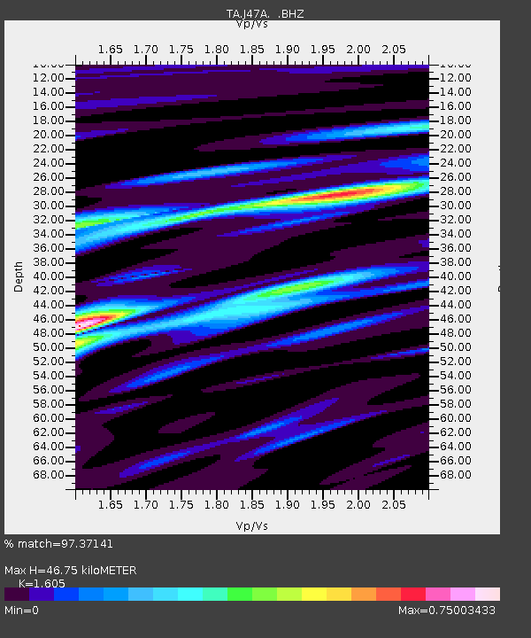
J47A Sunmer, MI, USA - Earthquake Result Viewer
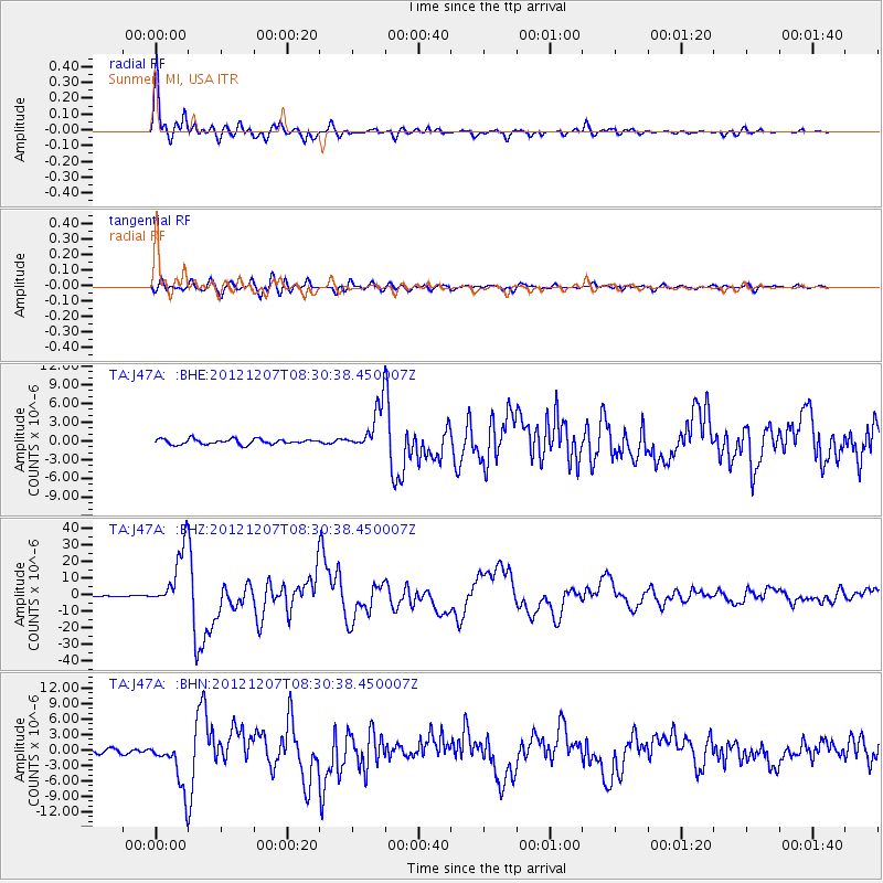
Earthquake location: Off East Coast Of Honshu, Japan
Earthquake latitude/longitude: 37.9/143.9
Earthquake time(UTC): 2012/12/07 (342) 08:18:23 GMT
Earthquake Depth: 31 km
Earthquake Magnitude: 7.2 MB, 7.3 MS, 7.3 MW, 7.3 MW
Earthquake Catalog/Contributor: WHDF/NEIC
Network: TA USArray Transportable Network (new EarthScope stations)
Station: J47A Sunmer, MI, USA
Lat/Lon: 43.24 N/84.82 W
Elevation: 236 m
Distance: 87.9 deg
Az: 33.366 deg
Baz: 323.457 deg
Ray Param: 0.042936277
Estimated Moho Depth: 46.75 km
Estimated Crust Vp/Vs: 1.61
Assumed Crust Vp: 6.483 km/s
Estimated Crust Vs: 4.039 km/s
Estimated Crust Poisson's Ratio: 0.18
Radial Match: 97.37141 %
Radial Bump: 400
Transverse Match: 89.143456 %
Transverse Bump: 400
SOD ConfigId: 488671
Insert Time: 2013-03-29 04:53:37.401 +0000
GWidth: 2.5
Max Bumps: 400
Tol: 0.001

Signal To Noise

ChannelStoNSTALTA
TA:J47A: :BHZ:20121207T08:30:38.450007Z41.506841.7999755E-54.3365756E-7
TA:J47A: :BHN:20121207T08:30:38.450007Z10.457084.7119574E-64.5059974E-7
TA:J47A: :BHE:20121207T08:30:38.450007Z9.0030733.6774468E-64.0846575E-7
Arrivals
Ps4.5 SECOND
PpPs18 SECOND
PsPs/PpSs23 SECOND