You are here: Home > Network List > TA - USArray Transportable Network (new EarthScope stations) Stations List
> Station TCOL CIGO, UAF Yankovich Road, Fairbanks, AK, USA > Earthquake Result Viewer
TCOL CIGO, UAF Yankovich Road, Fairbanks, AK, USA - Earthquake Result Viewer
| Earthquake location: |
Off East Coast Of Honshu, Japan |
| Earthquake latitude/longitude: |
37.9/143.9 |
| Earthquake time(UTC): |
2012/12/07 (342) 08:18:23 GMT |
| Earthquake Depth: |
31 km |
| Earthquake Magnitude: |
7.2 MB, 7.3 MS, 7.3 MW, 7.3 MW |
| Earthquake Catalog/Contributor: |
WHDF/NEIC |
|
| Network: |
TA USArray Transportable Network (new EarthScope stations) |
| Station: |
TCOL CIGO, UAF Yankovich Road, Fairbanks, AK, USA |
| Lat/Lon: |
64.87 N/147.86 W |
| Elevation: |
178 m |
|
| Distance: |
47.3 deg |
| Az: |
32.659 deg |
| Baz: |
269.633 deg |
| Ray Param: |
0.0700407 |
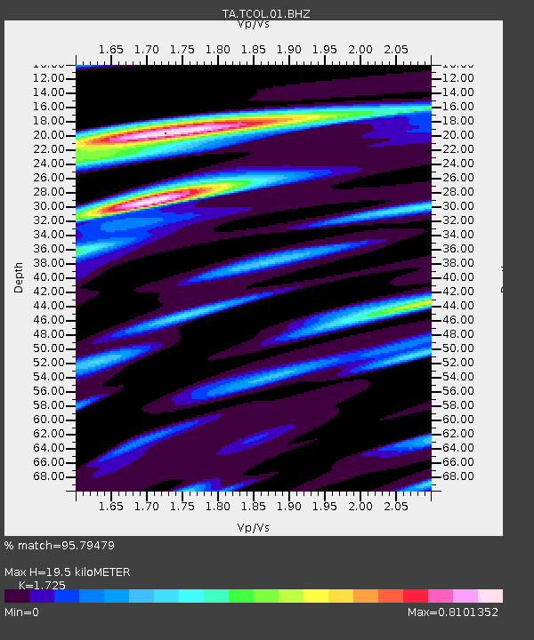
| Estimated Moho Depth: |
19.5 km |
| Estimated Crust Vp/Vs: |
1.73 |
| Assumed Crust Vp: |
6.566 km/s |
| Estimated Crust Vs: |
3.806 km/s |
| Estimated Crust Poisson's Ratio: |
0.25 |
|
| Radial Match: |
95.79479 % |
| Radial Bump: |
400 |
| Transverse Match: |
67.77159 % |
| Transverse Bump: |
400 |
| SOD ConfigId: |
488671 |
| Insert Time: |
2013-03-29 04:53:56.680 +0000 |
| GWidth: |
2.5 |
| Max Bumps: |
400 |
| Tol: |
0.001 |
|

Signal To Noise
| Channel | StoN | STA | LTA |
| TA:TCOL:01:BHZ:20121207T08:26:22.874995Z | 258.97794 | 3.4285888E-5 | 1.3238922E-7 |
| TA:TCOL:01:BHN:20121207T08:26:22.874995Z | 19.192251 | 2.6594787E-6 | 1.3857044E-7 |
| TA:TCOL:01:BHE:20121207T08:26:22.874995Z | 116.95993 | 1.8745774E-5 | 1.6027518E-7 |
| Arrivals |
| Ps | 2.3 SECOND |
| PpPs | 7.6 SECOND |
| PsPs/PpSs | 9.9 SECOND |


