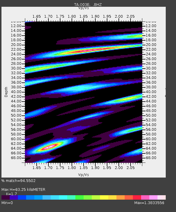
O03E Paynes Creek, CA, USA - Earthquake Result Viewer
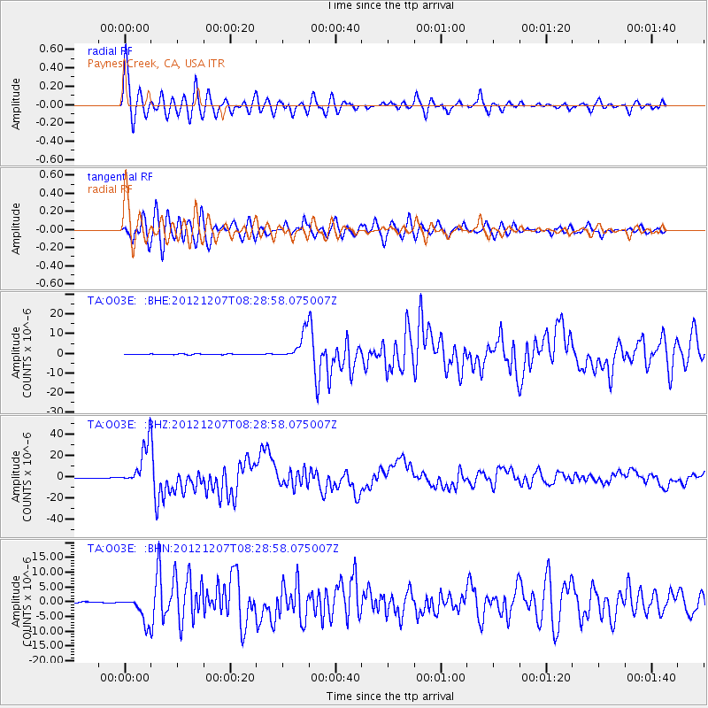
Earthquake location: Off East Coast Of Honshu, Japan
Earthquake latitude/longitude: 37.9/143.9
Earthquake time(UTC): 2012/12/07 (342) 08:18:23 GMT
Earthquake Depth: 31 km
Earthquake Magnitude: 7.2 MB, 7.3 MS, 7.3 MW, 7.3 MW
Earthquake Catalog/Contributor: WHDF/NEIC
Network: TA USArray Transportable Network (new EarthScope stations)
Station: O03E Paynes Creek, CA, USA
Lat/Lon: 40.29 N/121.80 W
Elevation: 967 m
Distance: 69.6 deg
Az: 54.487 deg
Baz: 302.649 deg
Ray Param: 0.05551664
Estimated Moho Depth: 63.25 km
Estimated Crust Vp/Vs: 1.70
Assumed Crust Vp: 6.566 km/s
Estimated Crust Vs: 3.862 km/s
Estimated Crust Poisson's Ratio: 0.24
Radial Match: 94.5502 %
Radial Bump: 400
Transverse Match: 91.073364 %
Transverse Bump: 400
SOD ConfigId: 488671
Insert Time: 2013-03-29 04:54:00.139 +0000
GWidth: 2.5
Max Bumps: 400
Tol: 0.001

Signal To Noise

ChannelStoNSTALTA
TA:O03E: :BHZ:20121207T08:28:58.075007Z120.4207462.0216527E-51.6788242E-7
TA:O03E: :BHN:20121207T08:28:58.075007Z19.806834.580071E-62.3123695E-7
TA:O03E: :BHE:20121207T08:28:58.075007Z38.8932466.9891125E-61.796999E-7
Arrivals
Ps7.0 SECOND
PpPs25 SECOND
PsPs/PpSs32 SECOND