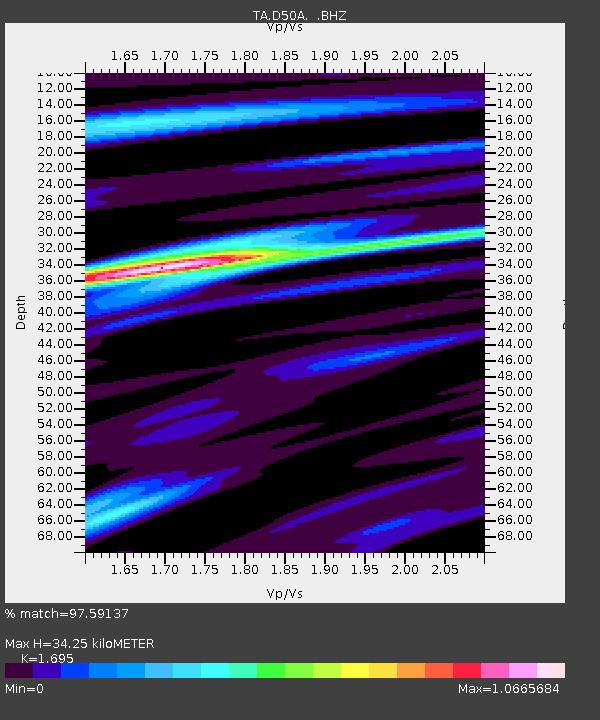
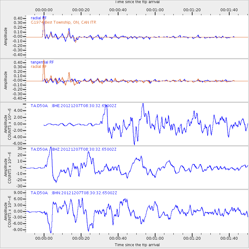
D50A G1974 Best Township, ON, CAN - Earthquake Result Viewer

Earthquake location: Off East Coast Of Honshu, Japan
Earthquake latitude/longitude: 37.9/143.9
Earthquake time(UTC): 2012/12/07 (342) 08:18:23 GMT
Earthquake Depth: 31 km
Earthquake Magnitude: 7.2 MB, 7.3 MS, 7.3 MW, 7.3 MW
Earthquake Catalog/Contributor: WHDF/NEIC
Network: TA USArray Transportable Network (new EarthScope stations)
Station: D50A G1974 Best Township, ON, CAN
Lat/Lon: 47.17 N/79.84 W
Elevation: 331 m
Distance: 86.7 deg
Az: 28.226 deg
Baz: 326.741 deg
Ray Param: 0.04381502
Estimated Moho Depth: 34.25 km
Estimated Crust Vp/Vs: 1.70
Assumed Crust Vp: 6.622 km/s
Estimated Crust Vs: 3.907 km/s
Estimated Crust Poisson's Ratio: 0.23
Radial Match: 97.59137 %
Radial Bump: 369
Transverse Match: 91.30406 %
Transverse Bump: 400
SOD ConfigId: 488671
Insert Time: 2013-03-29 04:54:43.784 +0000
GWidth: 2.5
Max Bumps: 400
Tol: 0.001

Signal To Noise

ChannelStoNSTALTA
TA:D50A: :BHZ:20121207T08:30:32.65002Z53.3169671.6618074E-53.1168454E-7
TA:D50A: :BHN:20121207T08:30:32.65002Z23.926334.946405E-62.0673481E-7
TA:D50A: :BHE:20121207T08:30:32.65002Z14.223722.9940445E-62.104966E-7
Arrivals
Ps3.7 SECOND
PpPs14 SECOND
PsPs/PpSs17 SECOND