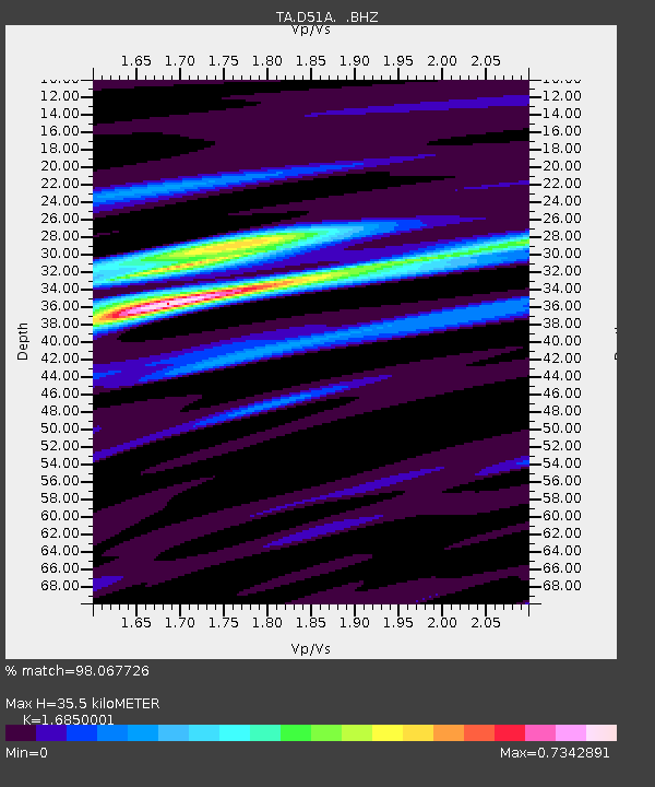
D51A Lot 18 Range III Mazenod Township, QC, CAN - Earthquake Result Viewer

Earthquake location: Off East Coast Of Honshu, Japan
Earthquake latitude/longitude: 37.9/143.9
Earthquake time(UTC): 2012/12/07 (342) 08:18:23 GMT
Earthquake Depth: 31 km
Earthquake Magnitude: 7.2 MB, 7.3 MS, 7.3 MW, 7.3 MW
Earthquake Catalog/Contributor: WHDF/NEIC
Network: TA USArray Transportable Network (new EarthScope stations)
Station: D51A Lot 18 Range III Mazenod Township, QC, CAN
Lat/Lon: 47.09 N/79.37 W
Elevation: 282 m
Distance: 86.9 deg
Az: 28.0 deg
Baz: 327.071 deg
Ray Param: 0.0436404
Estimated Moho Depth: 35.5 km
Estimated Crust Vp/Vs: 1.69
Assumed Crust Vp: 6.622 km/s
Estimated Crust Vs: 3.93 km/s
Estimated Crust Poisson's Ratio: 0.23
Radial Match: 98.067726 %
Radial Bump: 347
Transverse Match: 86.606384 %
Transverse Bump: 400
SOD ConfigId: 488671
Insert Time: 2013-03-29 04:54:53.632 +0000
GWidth: 2.5
Max Bumps: 400
Tol: 0.001

Signal To Noise

ChannelStoNSTALTA
TA:D51A: :BHZ:20121207T08:30:33.799983Z41.7417831.644044E-53.938605E-7
TA:D51A: :BHN:20121207T08:30:33.799983Z10.73417954.5852044E-64.2715928E-7
TA:D51A: :BHE:20121207T08:30:33.799983Z9.602712.8345803E-62.9518546E-7
Arrivals
Ps3.8 SECOND
PpPs14 SECOND
PsPs/PpSs18 SECOND