You are here: Home > Network List > TA - USArray Transportable Network (new EarthScope stations) Stations List
> Station W54A Cherokee Point, Campobello, SC, USA > Earthquake Result Viewer
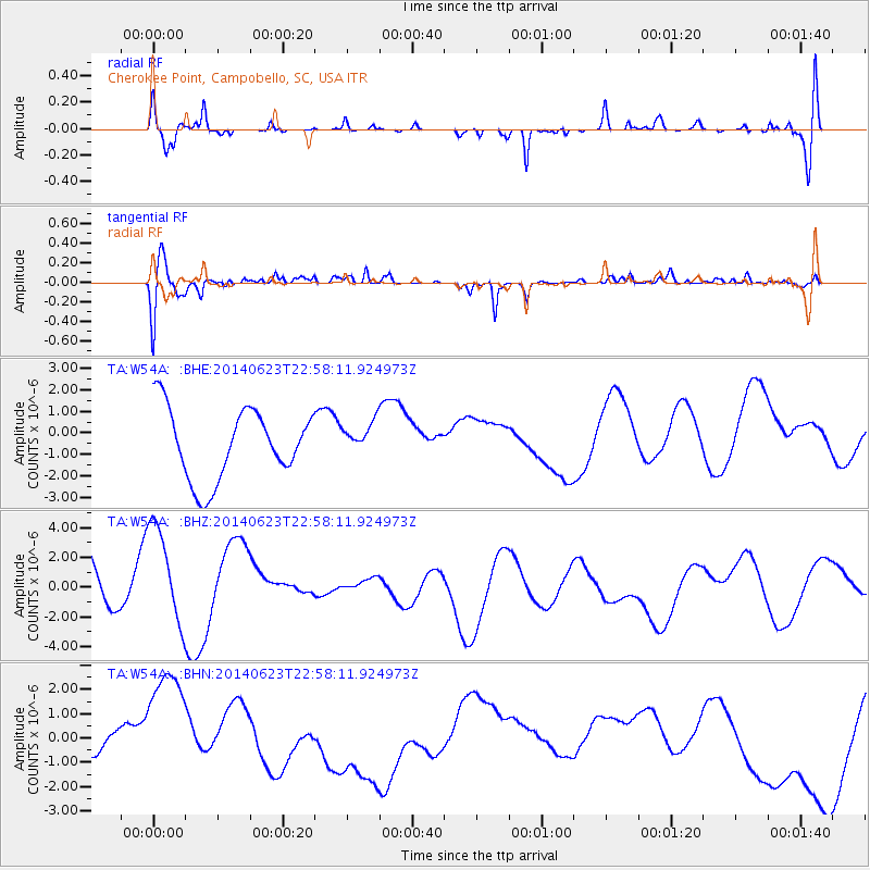
W54A Cherokee Point, Campobello, SC, USA - Earthquake Result Viewer
*The percent match for this event was below the threshold and hence no stack was calculated.
| Earthquake location: |
Rat Islands, Aleutian Islands |
| Earthquake latitude/longitude: |
52.0/178.4 |
| Earthquake time(UTC): |
2014/06/23 (174) 22:47:53 GMT |
| Earthquake Depth: |
116 km |
| Earthquake Magnitude: |
4.8 mb |
| Earthquake Catalog/Contributor: |
ISC/ISC |
|
| Network: |
TA USArray Transportable Network (new EarthScope stations) |
| Station: |
W54A Cherokee Point, Campobello, SC, USA |
| Lat/Lon: |
35.09 N/82.19 W |
| Elevation: |
272 m |
|
| Distance: |
68.5 deg |
| Az: |
60.429 deg |
| Baz: |
319.053 deg |
| Ray Param: |
$rayparam |
*The percent match for this event was below the threshold and hence was not used in the summary stack. |
|
| Radial Match: |
52.754513 % |
| Radial Bump: |
400 |
| Transverse Match: |
59.7827 % |
| Transverse Bump: |
400 |
| SOD ConfigId: |
3390531 |
| Insert Time: |
2019-04-12 11:49:47.473 +0000 |
| GWidth: |
2.5 |
| Max Bumps: |
400 |
| Tol: |
0.001 |
|
Signal To Noise
| Channel | StoN | STA | LTA |
| TA:W54A: :BHZ:20140623T22:58:11.924973Z | 1.3429834 | 3.7363557E-6 | 2.782131E-6 |
| TA:W54A: :BHN:20140623T22:58:11.924973Z | 4.8817983 | 2.9710093E-6 | 6.085891E-7 |
| TA:W54A: :BHE:20140623T22:58:11.924973Z | 0.4703555 | 7.6948504E-7 | 1.6359647E-6 |
| Arrivals |
| Ps | |
| PpPs | |
| PsPs/PpSs | |


