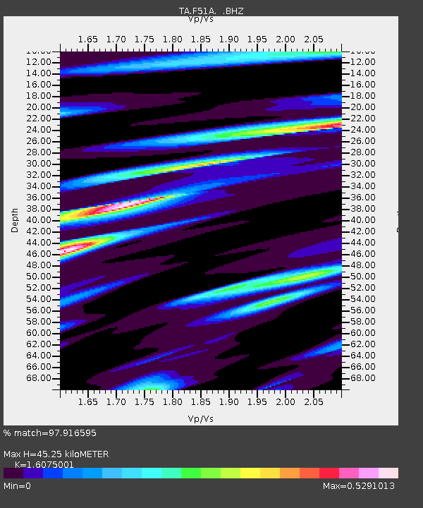
F51A Arnstein, ON, CAN - Earthquake Result Viewer
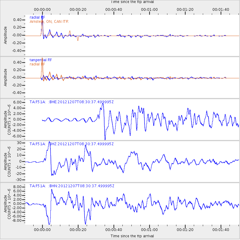
Earthquake location: Off East Coast Of Honshu, Japan
Earthquake latitude/longitude: 37.9/143.9
Earthquake time(UTC): 2012/12/07 (342) 08:18:23 GMT
Earthquake Depth: 31 km
Earthquake Magnitude: 7.2 MB, 7.3 MS, 7.3 MW, 7.3 MW
Earthquake Catalog/Contributor: WHDF/NEIC
Network: TA USArray Transportable Network (new EarthScope stations)
Station: F51A Arnstein, ON, CAN
Lat/Lon: 45.93 N/79.92 W
Elevation: 239 m
Distance: 87.7 deg
Az: 28.949 deg
Baz: 326.723 deg
Ray Param: 0.04308326
Estimated Moho Depth: 45.25 km
Estimated Crust Vp/Vs: 1.61
Assumed Crust Vp: 6.577 km/s
Estimated Crust Vs: 4.091 km/s
Estimated Crust Poisson's Ratio: 0.18
Radial Match: 97.916595 %
Radial Bump: 291
Transverse Match: 88.24772 %
Transverse Bump: 400
SOD ConfigId: 488671
Insert Time: 2013-03-29 04:55:24.840 +0000
GWidth: 2.5
Max Bumps: 400
Tol: 0.001

Signal To Noise

ChannelStoNSTALTA
TA:F51A: :BHZ:20121207T08:30:37.499995Z31.083821.6442726E-55.289802E-7
TA:F51A: :BHN:20121207T08:30:37.499995Z14.8586984.7987073E-63.229561E-7
TA:F51A: :BHE:20121207T08:30:37.499995Z8.2133283.059233E-63.724718E-7
Arrivals
Ps4.3 SECOND
PpPs17 SECOND
PsPs/PpSs22 SECOND