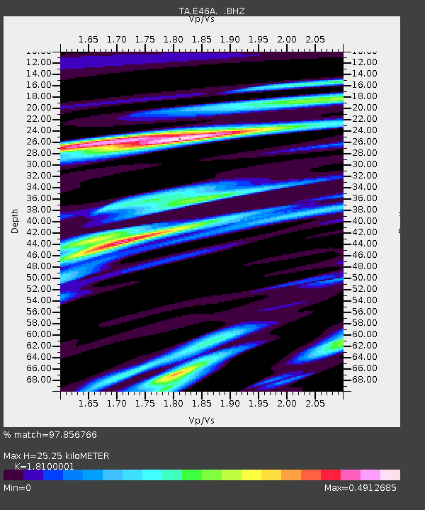
E46A Sault Ste Marie, MI, USA - Earthquake Result Viewer
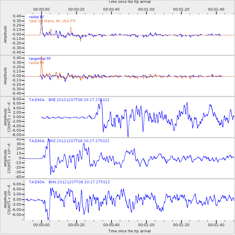
Earthquake location: Off East Coast Of Honshu, Japan
Earthquake latitude/longitude: 37.9/143.9
Earthquake time(UTC): 2012/12/07 (342) 08:18:23 GMT
Earthquake Depth: 31 km
Earthquake Magnitude: 7.2 MB, 7.3 MS, 7.3 MW, 7.3 MW
Earthquake Catalog/Contributor: WHDF/NEIC
Network: TA USArray Transportable Network (new EarthScope stations)
Station: E46A Sault Ste Marie, MI, USA
Lat/Lon: 46.37 N/84.31 W
Elevation: 269 m
Distance: 85.6 deg
Az: 31.21 deg
Baz: 323.697 deg
Ray Param: 0.044597734
Estimated Moho Depth: 25.25 km
Estimated Crust Vp/Vs: 1.81
Assumed Crust Vp: 6.467 km/s
Estimated Crust Vs: 3.573 km/s
Estimated Crust Poisson's Ratio: 0.28
Radial Match: 97.856766 %
Radial Bump: 333
Transverse Match: 93.45041 %
Transverse Bump: 400
SOD ConfigId: 488671
Insert Time: 2013-03-29 04:56:39.495 +0000
GWidth: 2.5
Max Bumps: 400
Tol: 0.001

Signal To Noise

ChannelStoNSTALTA
TA:E46A: :BHZ:20121207T08:30:27.27502Z50.495412.0034864E-53.96766E-7
TA:E46A: :BHN:20121207T08:30:27.27502Z14.8024285.5558116E-63.753311E-7
TA:E46A: :BHE:20121207T08:30:27.27502Z18.102013.9802003E-62.1987614E-7
Arrivals
Ps3.2 SECOND
PpPs11 SECOND
PsPs/PpSs14 SECOND