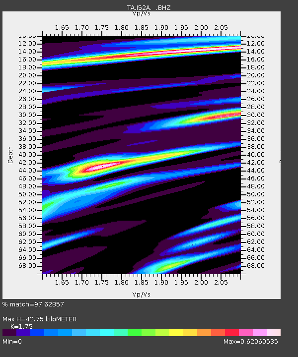
I52A Shelburne, ON, CAN - Earthquake Result Viewer

Earthquake location: Off East Coast Of Honshu, Japan
Earthquake latitude/longitude: 37.9/143.9
Earthquake time(UTC): 2012/12/07 (342) 08:18:23 GMT
Earthquake Depth: 31 km
Earthquake Magnitude: 7.2 MB, 7.3 MS, 7.3 MW, 7.3 MW
Earthquake Catalog/Contributor: WHDF/NEIC
Network: TA USArray Transportable Network (new EarthScope stations)
Station: I52A Shelburne, ON, CAN
Lat/Lon: 44.07 N/80.18 W
Elevation: 505 m
Distance: 89.2 deg
Az: 30.128 deg
Baz: 326.57 deg
Ray Param: 0.04200882
Estimated Moho Depth: 42.75 km
Estimated Crust Vp/Vs: 1.75
Assumed Crust Vp: 6.53 km/s
Estimated Crust Vs: 3.732 km/s
Estimated Crust Poisson's Ratio: 0.26
Radial Match: 97.62857 %
Radial Bump: 380
Transverse Match: 89.11735 %
Transverse Bump: 400
SOD ConfigId: 488671
Insert Time: 2013-03-29 04:57:03.376 +0000
GWidth: 2.5
Max Bumps: 400
Tol: 0.001

Signal To Noise

ChannelStoNSTALTA
TA:I52A: :BHZ:20121207T08:30:44.374995Z15.023651.482414E-59.867202E-7
TA:I52A: :BHN:20121207T08:30:44.374995Z5.6201314.6627565E-68.2965255E-7
TA:I52A: :BHE:20121207T08:30:44.374995Z3.18966222.6537396E-68.319814E-7
Arrivals
Ps5.0 SECOND
PpPs18 SECOND
PsPs/PpSs23 SECOND