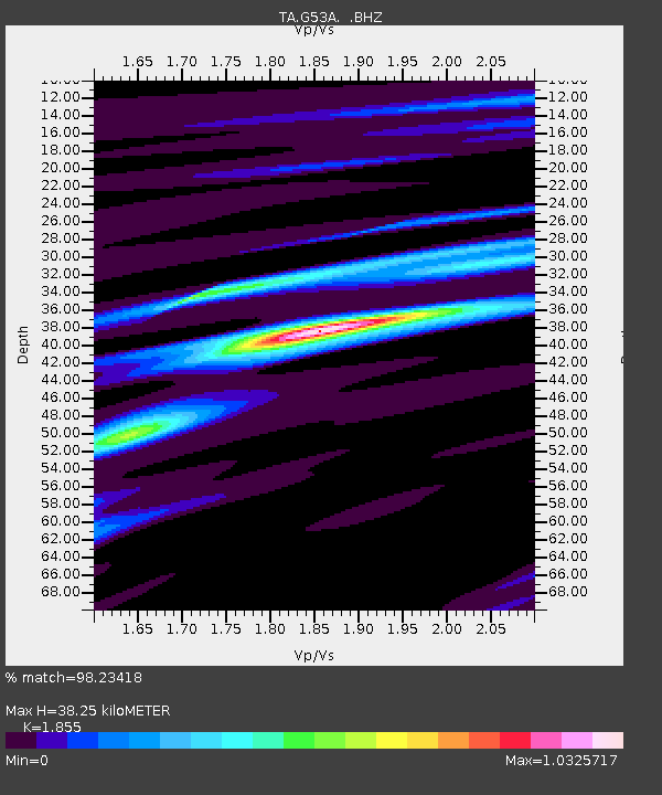
G53A Haliburton, ON, CAN - Earthquake Result Viewer

Earthquake location: Off East Coast Of Honshu, Japan
Earthquake latitude/longitude: 37.9/143.9
Earthquake time(UTC): 2012/12/07 (342) 08:18:23 GMT
Earthquake Depth: 31 km
Earthquake Magnitude: 7.2 MB, 7.3 MS, 7.3 MW, 7.3 MW
Earthquake Catalog/Contributor: WHDF/NEIC
Network: TA USArray Transportable Network (new EarthScope stations)
Station: G53A Haliburton, ON, CAN
Lat/Lon: 45.12 N/78.62 W
Elevation: 333 m
Distance: 88.9 deg
Az: 28.624 deg
Baz: 327.632 deg
Ray Param: 0.04221438
Estimated Moho Depth: 38.25 km
Estimated Crust Vp/Vs: 1.86
Assumed Crust Vp: 6.577 km/s
Estimated Crust Vs: 3.546 km/s
Estimated Crust Poisson's Ratio: 0.30
Radial Match: 98.23418 %
Radial Bump: 205
Transverse Match: 87.016754 %
Transverse Bump: 400
SOD ConfigId: 488671
Insert Time: 2013-03-29 04:57:12.316 +0000
GWidth: 2.5
Max Bumps: 400
Tol: 0.001

Signal To Noise

ChannelStoNSTALTA
TA:G53A: :BHZ:20121207T08:30:43.049983Z28.0106451.6447359E-55.8718246E-7
TA:G53A: :BHN:20121207T08:30:43.049983Z10.9057424.9018213E-64.494716E-7
TA:G53A: :BHE:20121207T08:30:43.049983Z13.8812273.3813049E-62.4358835E-7
Arrivals
Ps5.1 SECOND
PpPs16 SECOND
PsPs/PpSs21 SECOND