HOOD Mt Hood Meadows, OR CREST BB SMO - Earthquake Result Viewer
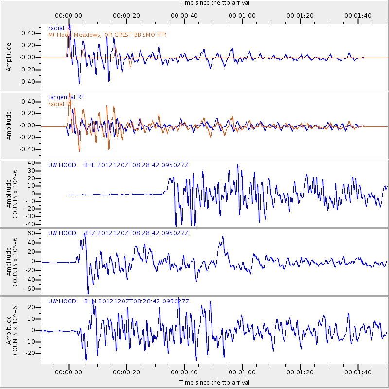
Earthquake location: Off East Coast Of Honshu, Japan
Earthquake latitude/longitude: 37.9/143.9
Earthquake time(UTC): 2012/12/07 (342) 08:18:23 GMT
Earthquake Depth: 31 km
Earthquake Magnitude: 7.2 MB, 7.3 MS, 7.3 MW, 7.3 MW
Earthquake Catalog/Contributor: WHDF/NEIC
Network: UW Pacific Northwest Regional Seismic Network
Station: HOOD Mt Hood Meadows, OR CREST BB SMO
Lat/Lon: 45.32 N/121.65 W
Elevation: 1520 m
Distance: 67.0 deg
Az: 49.831 deg
Baz: 301.025 deg
Ray Param: 0.057190746
Estimated Moho Depth: 29.5 km
Estimated Crust Vp/Vs: 2.10
Assumed Crust Vp: 6.597 km/s
Estimated Crust Vs: 3.145 km/s
Estimated Crust Poisson's Ratio: 0.35
Radial Match: 93.69899 %
Radial Bump: 400
Transverse Match: 90.7978 %
Transverse Bump: 400
SOD ConfigId: 488671
Insert Time: 2013-03-29 04:58:36.794 +0000
GWidth: 2.5
Max Bumps: 400
Tol: 0.001

Signal To Noise

ChannelStoNSTALTA
UW:HOOD: :BHZ:20121207T08:28:42.095027Z46.652221.6748269E-53.590026E-7
UW:HOOD: :BHN:20121207T08:28:42.095027Z11.8035943.7419966E-63.170218E-7
UW:HOOD: :BHE:20121207T08:28:42.095027Z11.3923555.9413005E-65.215165E-7
Arrivals
Ps5.1 SECOND
PpPs13 SECOND
PsPs/PpSs18 SECOND