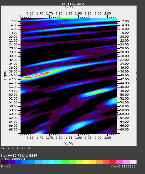
MRBL Marblemount, WA, USA - Earthquake Result Viewer
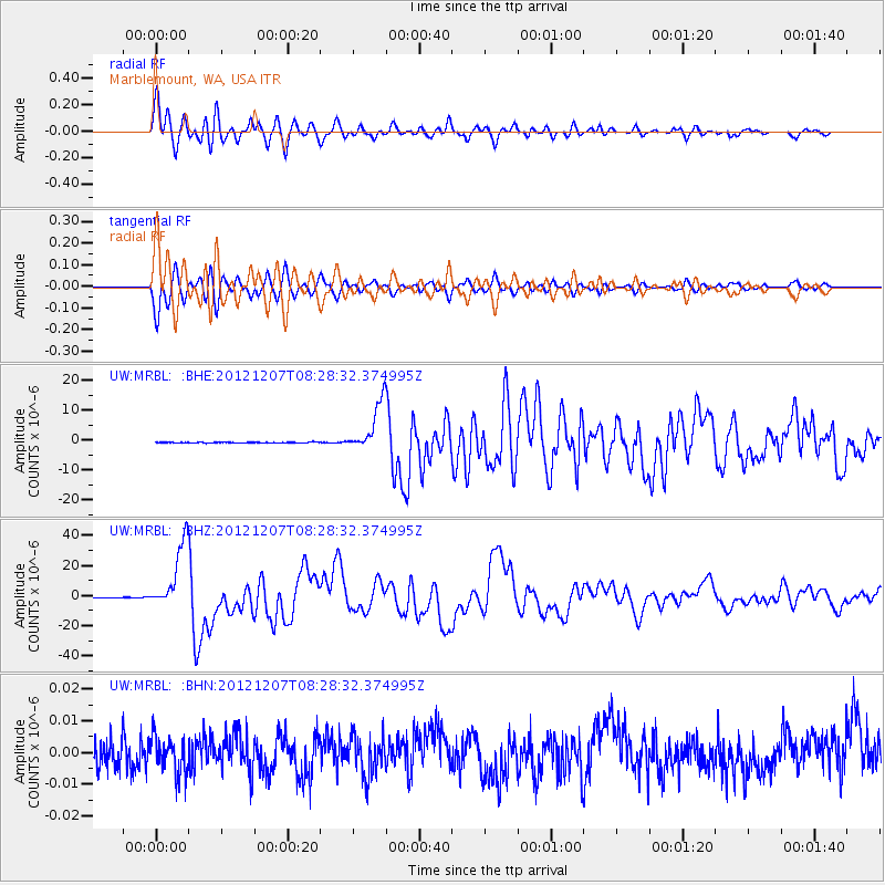
Earthquake location: Off East Coast Of Honshu, Japan
Earthquake latitude/longitude: 37.9/143.9
Earthquake time(UTC): 2012/12/07 (342) 08:18:23 GMT
Earthquake Depth: 31 km
Earthquake Magnitude: 7.2 MB, 7.3 MS, 7.3 MW, 7.3 MW
Earthquake Catalog/Contributor: WHDF/NEIC
Network: UW Pacific Northwest Regional Seismic Network
Station: MRBL Marblemount, WA, USA
Lat/Lon: 48.52 N/121.48 W
Elevation: 75 m
Distance: 65.5 deg
Az: 46.755 deg
Baz: 299.909 deg
Ray Param: 0.058193255
Estimated Moho Depth: 39.75 km
Estimated Crust Vp/Vs: 1.68
Assumed Crust Vp: 6.566 km/s
Estimated Crust Vs: 3.908 km/s
Estimated Crust Poisson's Ratio: 0.23
Radial Match: 90.26168 %
Radial Bump: 400
Transverse Match: 90.230446 %
Transverse Bump: 400
SOD ConfigId: 488671
Insert Time: 2013-03-29 04:58:48.548 +0000
GWidth: 2.5
Max Bumps: 400
Tol: 0.001

Signal To Noise

ChannelStoNSTALTA
UW:MRBL: :BHZ:20121207T08:28:32.374995Z182.808122.2042104E-51.205751E-7
UW:MRBL: :BHN:20121207T08:28:32.374995Z1.14335545.599287E-94.8972413E-9
UW:MRBL: :BHE:20121207T08:28:32.374995Z68.003518.272008E-61.2164091E-7
Arrivals
Ps4.3 SECOND
PpPs15 SECOND
PsPs/PpSs20 SECOND