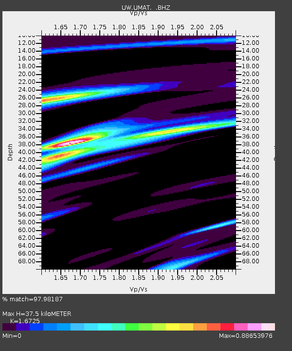
UMAT Pilot Rock, OR, USA - Earthquake Result Viewer
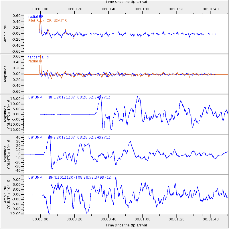
Earthquake location: Off East Coast Of Honshu, Japan
Earthquake latitude/longitude: 37.9/143.9
Earthquake time(UTC): 2012/12/07 (342) 08:18:23 GMT
Earthquake Depth: 31 km
Earthquake Magnitude: 7.2 MB, 7.3 MS, 7.3 MW, 7.3 MW
Earthquake Catalog/Contributor: WHDF/NEIC
Network: UW Pacific Northwest Regional Seismic Network
Station: UMAT Pilot Rock, OR, USA
Lat/Lon: 45.29 N/118.96 W
Elevation: 1318 m
Distance: 68.6 deg
Az: 48.778 deg
Baz: 302.537 deg
Ray Param: 0.056126304
Estimated Moho Depth: 37.5 km
Estimated Crust Vp/Vs: 1.67
Assumed Crust Vp: 6.571 km/s
Estimated Crust Vs: 3.929 km/s
Estimated Crust Poisson's Ratio: 0.22
Radial Match: 97.98187 %
Radial Bump: 325
Transverse Match: 90.47833 %
Transverse Bump: 400
SOD ConfigId: 488671
Insert Time: 2013-03-29 04:59:01.603 +0000
GWidth: 2.5
Max Bumps: 400
Tol: 0.001

Signal To Noise

ChannelStoNSTALTA
UW:UMAT: :BHZ:20121207T08:28:52.349971Z118.8119351.5219369E-51.280963E-7
UW:UMAT: :BHN:20121207T08:28:52.349971Z26.640053.989235E-61.4974577E-7
UW:UMAT: :BHE:20121207T08:28:52.349971Z54.3028035.752291E-61.0592991E-7
Arrivals
Ps4.0 SECOND
PpPs15 SECOND
PsPs/PpSs19 SECOND