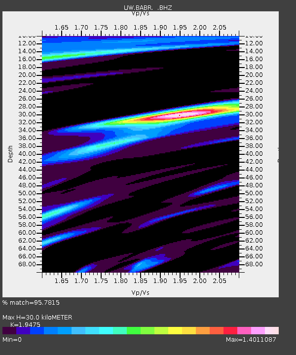
BABR Baber Butte, OR, USA - Earthquake Result Viewer

Earthquake location: Off East Coast Of Honshu, Japan
Earthquake latitude/longitude: 37.9/143.9
Earthquake time(UTC): 2012/12/07 (342) 08:18:23 GMT
Earthquake Depth: 31 km
Earthquake Magnitude: 7.2 MB, 7.3 MS, 7.3 MW, 7.3 MW
Earthquake Catalog/Contributor: WHDF/NEIC
Network: UW Pacific Northwest Regional Seismic Network
Station: BABR Baber Butte, OR, USA
Lat/Lon: 44.62 N/123.79 W
Elevation: 418 m
Distance: 66.1 deg
Az: 51.329 deg
Baz: 300.117 deg
Ray Param: 0.05781784
Estimated Moho Depth: 30.0 km
Estimated Crust Vp/Vs: 1.95
Assumed Crust Vp: 6.566 km/s
Estimated Crust Vs: 3.372 km/s
Estimated Crust Poisson's Ratio: 0.32
Radial Match: 95.7815 %
Radial Bump: 400
Transverse Match: 90.19378 %
Transverse Bump: 400
SOD ConfigId: 488671
Insert Time: 2013-03-29 05:00:22.086 +0000
GWidth: 2.5
Max Bumps: 400
Tol: 0.001

Signal To Noise

ChannelStoNSTALTA
UW:BABR: :BHZ:20121207T08:28:36.064998Z14.65343951.5513677E-51.0587055E-6
UW:BABR: :BHN:20121207T08:28:36.064998Z1.58302782.0299753E-61.282337E-6
UW:BABR: :BHE:20121207T08:28:36.064998Z4.2659044.2008555E-69.847515E-7
Arrivals
Ps4.5 SECOND
PpPs13 SECOND
PsPs/PpSs17 SECOND