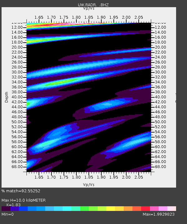
RADR Rader Ridge, WA - Earthquake Result Viewer

Earthquake location: Off East Coast Of Honshu, Japan
Earthquake latitude/longitude: 37.9/143.9
Earthquake time(UTC): 2012/12/07 (342) 08:18:23 GMT
Earthquake Depth: 31 km
Earthquake Magnitude: 7.2 MB, 7.3 MS, 7.3 MW, 7.3 MW
Earthquake Catalog/Contributor: WHDF/NEIC
Network: UW Pacific Northwest Regional Seismic Network
Station: RADR Rader Ridge, WA
Lat/Lon: 46.42 N/123.80 W
Elevation: 568 m
Distance: 65.2 deg
Az: 49.616 deg
Baz: 299.403 deg
Ray Param: 0.05840776
Estimated Moho Depth: 10.0 km
Estimated Crust Vp/Vs: 1.83
Assumed Crust Vp: 6.566 km/s
Estimated Crust Vs: 3.588 km/s
Estimated Crust Poisson's Ratio: 0.29
Radial Match: 92.55252 %
Radial Bump: 400
Transverse Match: 89.57104 %
Transverse Bump: 400
SOD ConfigId: 488671
Insert Time: 2013-03-29 05:00:26.178 +0000
GWidth: 2.5
Max Bumps: 400
Tol: 0.001

Signal To Noise

ChannelStoNSTALTA
UW:RADR: :BHZ:20121207T08:28:30.26501Z24.5820051.5438985E-56.280605E-7
UW:RADR: :BHN:20121207T08:28:30.26501Z4.4707813.519464E-67.8721456E-7
UW:RADR: :BHE:20121207T08:28:30.26501Z3.0860842.9027613E-69.4059703E-7
Arrivals
Ps1.3 SECOND
PpPs4.1 SECOND
PsPs/PpSs5.5 SECOND