You are here: Home > Network List > TA - USArray Transportable Network (new EarthScope stations) Stations List
> Station N59A State Game Land 141, Hazleton, PA, USA > Earthquake Result Viewer
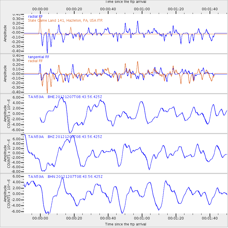
N59A State Game Land 141, Hazleton, PA, USA - Earthquake Result Viewer
*The percent match for this event was below the threshold and hence no stack was calculated.
| Earthquake location: |
Off East Coast Of Honshu, Japan |
| Earthquake latitude/longitude: |
37.9/143.8 |
| Earthquake time(UTC): |
2012/12/07 (342) 08:31:14 GMT |
| Earthquake Depth: |
32 km |
| Earthquake Magnitude: |
6.1 MB, 6.2 MW, 6.2 MW |
| Earthquake Catalog/Contributor: |
WHDF/NEIC |
|
| Network: |
TA USArray Transportable Network (new EarthScope stations) |
| Station: |
N59A State Game Land 141, Hazleton, PA, USA |
| Lat/Lon: |
40.92 N/75.77 W |
| Elevation: |
508 m |
|
| Distance: |
93.6 deg |
| Az: |
28.905 deg |
| Baz: |
329.704 deg |
| Ray Param: |
$rayparam |
*The percent match for this event was below the threshold and hence was not used in the summary stack. |
|
| Radial Match: |
48.417618 % |
| Radial Bump: |
340 |
| Transverse Match: |
59.494625 % |
| Transverse Bump: |
400 |
| SOD ConfigId: |
488671 |
| Insert Time: |
2013-03-29 05:08:40.356 +0000 |
| GWidth: |
2.5 |
| Max Bumps: |
400 |
| Tol: |
0.001 |
|
Signal To Noise
| Channel | StoN | STA | LTA |
| TA:N59A: :BHZ:20121207T08:43:56.425Z | 1.4683188 | 6.9968983E-6 | 4.7652447E-6 |
| TA:N59A: :BHN:20121207T08:43:56.425Z | 1.057968 | 4.460195E-6 | 4.2158126E-6 |
| TA:N59A: :BHE:20121207T08:43:56.425Z | 0.848357 | 3.2307937E-6 | 3.8082949E-6 |
| Arrivals |
| Ps | |
| PpPs | |
| PsPs/PpSs | |


