You are here: Home > Network List > TA - USArray Transportable Network (new EarthScope stations) Stations List
> Station 348A Jackson, AL, USA > Earthquake Result Viewer
348A Jackson, AL, USA - Earthquake Result Viewer
*The percent match for this event was below the threshold and hence no stack was calculated.
| Earthquake location: |
Off East Coast Of Honshu, Japan |
| Earthquake latitude/longitude: |
37.9/143.8 |
| Earthquake time(UTC): |
2012/12/07 (342) 08:31:14 GMT |
| Earthquake Depth: |
32 km |
| Earthquake Magnitude: |
6.1 MB, 6.2 MW, 6.2 MW |
| Earthquake Catalog/Contributor: |
WHDF/NEIC |
|
| Network: |
TA USArray Transportable Network (new EarthScope stations) |
| Station: |
348A Jackson, AL, USA |
| Lat/Lon: |
31.41 N/87.90 W |
| Elevation: |
57 m |
|
| Distance: |
95.9 deg |
| Az: |
42.391 deg |
| Baz: |
321.415 deg |
| Ray Param: |
$rayparam |
*The percent match for this event was below the threshold and hence was not used in the summary stack. |
|
| Radial Match: |
71.65623 % |
| Radial Bump: |
277 |
| Transverse Match: |
52.650482 % |
| Transverse Bump: |
400 |
| SOD ConfigId: |
488671 |
| Insert Time: |
2013-03-29 05:09:28.670 +0000 |
| GWidth: |
2.5 |
| Max Bumps: |
400 |
| Tol: |
0.001 |
|
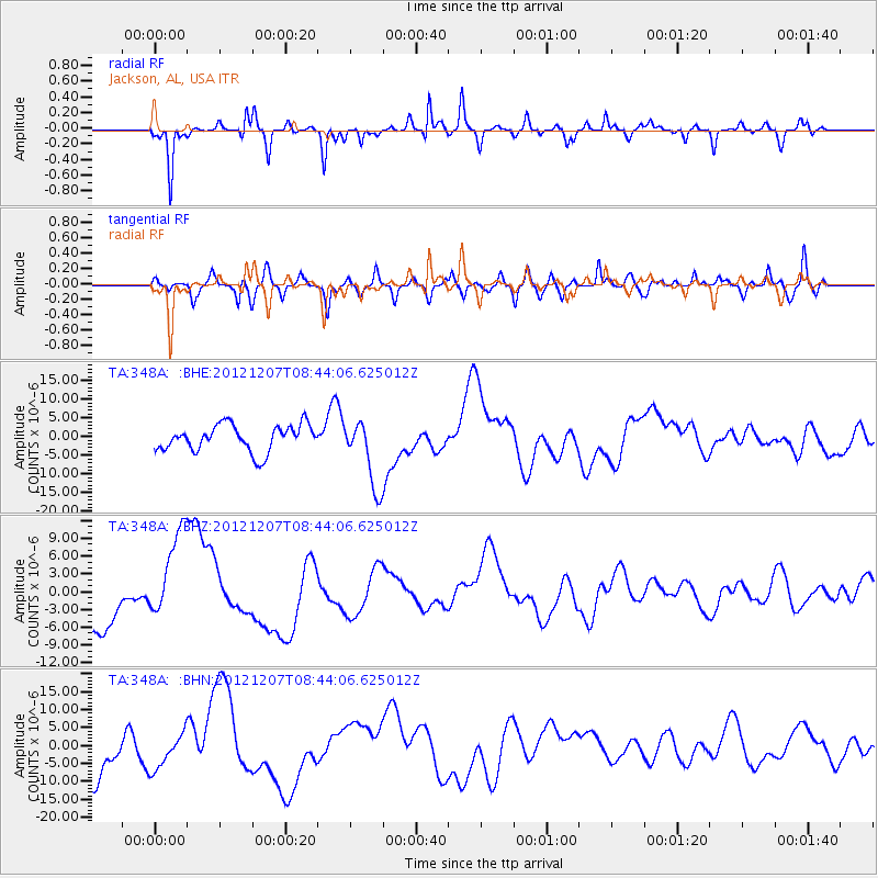
Signal To Noise
| Channel | StoN | STA | LTA |
| TA:348A: :BHZ:20121207T08:44:06.625012Z | 2.0374258 | 7.987177E-6 | 3.9202296E-6 |
| TA:348A: :BHN:20121207T08:44:06.625012Z | 1.0310079 | 4.869073E-6 | 4.722634E-6 |
| TA:348A: :BHE:20121207T08:44:06.625012Z | 2.6384687 | 9.256914E-6 | 3.5084418E-6 |
| Arrivals |
| Ps | |
| PpPs | |
| PsPs/PpSs | |


