You are here: Home > Network List > TA - USArray Transportable Network (new EarthScope stations) Stations List
> Station Z50A Ashland, AL, USA > Earthquake Result Viewer
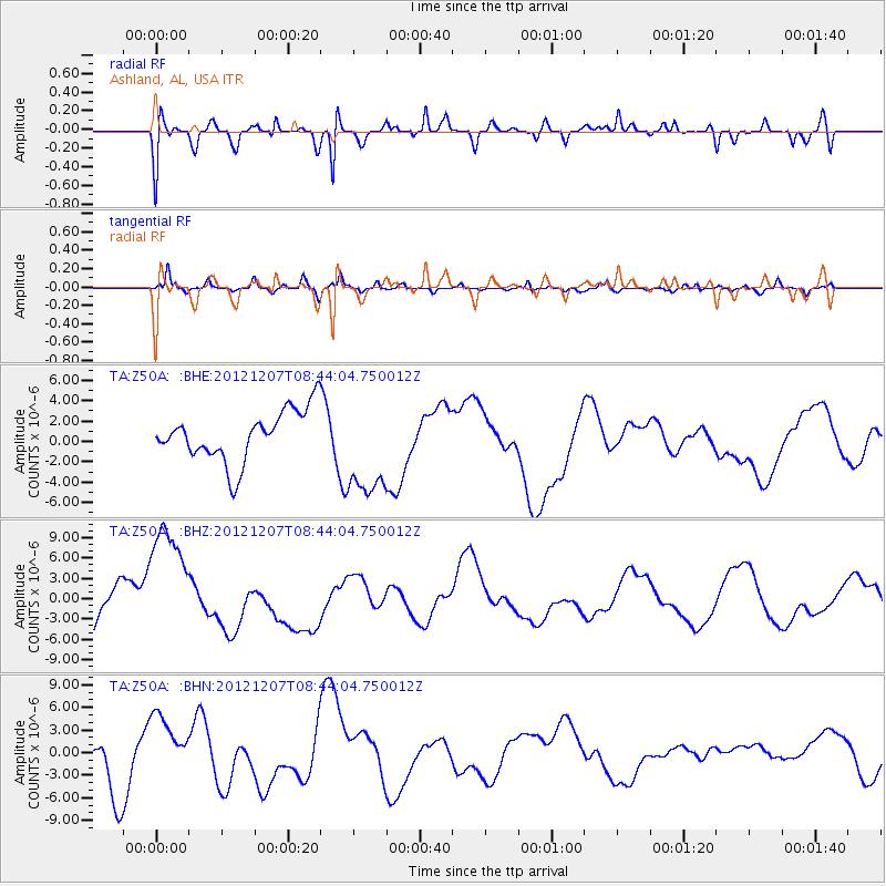
Z50A Ashland, AL, USA - Earthquake Result Viewer
*The percent match for this event was below the threshold and hence no stack was calculated.
| Earthquake location: |
Off East Coast Of Honshu, Japan |
| Earthquake latitude/longitude: |
37.9/143.8 |
| Earthquake time(UTC): |
2012/12/07 (342) 08:31:14 GMT |
| Earthquake Depth: |
32 km |
| Earthquake Magnitude: |
6.1 MB, 6.2 MW, 6.2 MW |
| Earthquake Catalog/Contributor: |
WHDF/NEIC |
|
| Network: |
TA USArray Transportable Network (new EarthScope stations) |
| Station: |
Z50A Ashland, AL, USA |
| Lat/Lon: |
33.25 N/85.92 W |
| Elevation: |
370 m |
|
| Distance: |
95.4 deg |
| Az: |
39.928 deg |
| Baz: |
322.712 deg |
| Ray Param: |
$rayparam |
*The percent match for this event was below the threshold and hence was not used in the summary stack. |
|
| Radial Match: |
61.485188 % |
| Radial Bump: |
398 |
| Transverse Match: |
61.56631 % |
| Transverse Bump: |
400 |
| SOD ConfigId: |
488671 |
| Insert Time: |
2013-03-29 05:10:52.951 +0000 |
| GWidth: |
2.5 |
| Max Bumps: |
400 |
| Tol: |
0.001 |
|
Signal To Noise
| Channel | StoN | STA | LTA |
| TA:Z50A: :BHZ:20121207T08:44:04.750012Z | 2.3026552 | 9.504334E-6 | 4.1275543E-6 |
| TA:Z50A: :BHN:20121207T08:44:04.750012Z | 1.6753007 | 4.28081E-6 | 2.5552488E-6 |
| TA:Z50A: :BHE:20121207T08:44:04.750012Z | 1.9794136 | 4.920015E-6 | 2.4855922E-6 |
| Arrivals |
| Ps | |
| PpPs | |
| PsPs/PpSs | |


