You are here: Home > Network List > TA - USArray Transportable Network (new EarthScope stations) Stations List
> Station 353A Camilla, GA, USA > Earthquake Result Viewer
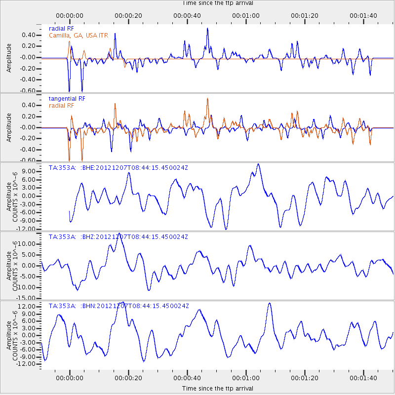
353A Camilla, GA, USA - Earthquake Result Viewer
*The percent match for this event was below the threshold and hence no stack was calculated.
| Earthquake location: |
Off East Coast Of Honshu, Japan |
| Earthquake latitude/longitude: |
37.9/143.8 |
| Earthquake time(UTC): |
2012/12/07 (342) 08:31:14 GMT |
| Earthquake Depth: |
32 km |
| Earthquake Magnitude: |
6.1 MB, 6.2 MW, 6.2 MW |
| Earthquake Catalog/Contributor: |
WHDF/NEIC |
|
| Network: |
TA USArray Transportable Network (new EarthScope stations) |
| Station: |
353A Camilla, GA, USA |
| Lat/Lon: |
31.35 N/84.22 W |
| Elevation: |
54 m |
|
| Distance: |
97.8 deg |
| Az: |
39.912 deg |
| Baz: |
323.621 deg |
| Ray Param: |
$rayparam |
*The percent match for this event was below the threshold and hence was not used in the summary stack. |
|
| Radial Match: |
68.80688 % |
| Radial Bump: |
348 |
| Transverse Match: |
60.7218 % |
| Transverse Bump: |
313 |
| SOD ConfigId: |
488671 |
| Insert Time: |
2013-03-29 05:11:49.775 +0000 |
| GWidth: |
2.5 |
| Max Bumps: |
400 |
| Tol: |
0.001 |
|
Signal To Noise
| Channel | StoN | STA | LTA |
| TA:353A: :BHZ:20121207T08:44:15.450024Z | 4.6364207 | 7.556297E-6 | 1.6297696E-6 |
| TA:353A: :BHN:20121207T08:44:15.450024Z | 0.7475719 | 2.8744166E-6 | 3.8450034E-6 |
| TA:353A: :BHE:20121207T08:44:15.450024Z | 1.124669 | 3.997749E-6 | 3.5546007E-6 |
| Arrivals |
| Ps | |
| PpPs | |
| PsPs/PpSs | |


