You are here: Home > Network List > AK - Alaska Regional Network Stations List
> Station MLY Manley Hot Springs, Alaska, USA > Earthquake Result Viewer
MLY Manley Hot Springs, Alaska, USA - Earthquake Result Viewer
| Earthquake location: |
Kermadec Islands, New Zealand |
| Earthquake latitude/longitude: |
-30.2/-177.5 |
| Earthquake time(UTC): |
2014/06/23 (174) 23:53:27 GMT |
| Earthquake Depth: |
10 km |
| Earthquake Magnitude: |
5.2 mb |
| Earthquake Catalog/Contributor: |
ISC/ISC |
|
| Network: |
AK Alaska Regional Network |
| Station: |
MLY Manley Hot Springs, Alaska, USA |
| Lat/Lon: |
65.03 N/150.74 W |
| Elevation: |
804 m |
|
| Distance: |
97.1 deg |
| Az: |
11.095 deg |
| Baz: |
203.12 deg |
| Ray Param: |
0.040304046 |
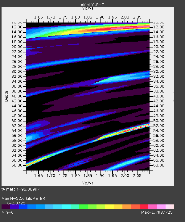
| Estimated Moho Depth: |
52.0 km |
| Estimated Crust Vp/Vs: |
2.07 |
| Assumed Crust Vp: |
6.566 km/s |
| Estimated Crust Vs: |
3.168 km/s |
| Estimated Crust Poisson's Ratio: |
0.35 |
|
| Radial Match: |
96.08997 % |
| Radial Bump: |
371 |
| Transverse Match: |
71.4805 % |
| Transverse Bump: |
400 |
| SOD ConfigId: |
3390531 |
| Insert Time: |
2019-04-12 11:53:19.092 +0000 |
| GWidth: |
2.5 |
| Max Bumps: |
400 |
| Tol: |
0.001 |
|

Signal To Noise
| Channel | StoN | STA | LTA |
| AK:MLY: :BHZ:20140624T00:06:27.728Z | 1.3344653 | 1.0251254E-6 | 7.6819185E-7 |
| AK:MLY: :BHN:20140624T00:06:27.728Z | 1.3804396 | 1.820805E-6 | 1.3190037E-6 |
| AK:MLY: :BHE:20140624T00:06:27.728Z | 1.8320017 | 4.0626255E-6 | 2.2175884E-6 |
| Arrivals |
| Ps | 8.6 SECOND |
| PpPs | 24 SECOND |
| PsPs/PpSs | 33 SECOND |


