You are here: Home > Network List > TA - USArray Transportable Network (new EarthScope stations) Stations List
> Station V53A Saluda, NC, USA > Earthquake Result Viewer
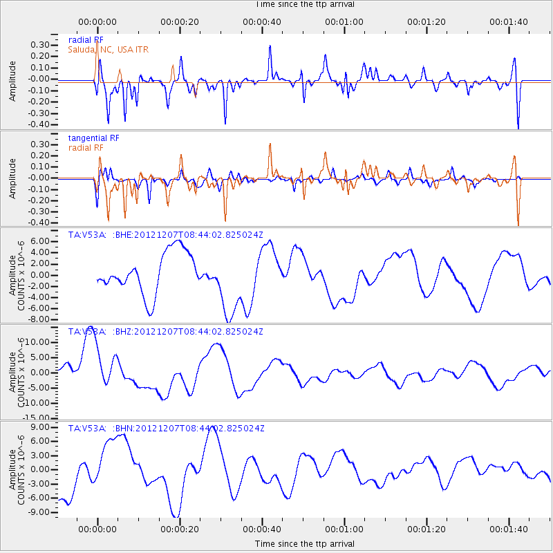
V53A Saluda, NC, USA - Earthquake Result Viewer
*The percent match for this event was below the threshold and hence no stack was calculated.
| Earthquake location: |
Off East Coast Of Honshu, Japan |
| Earthquake latitude/longitude: |
37.9/143.8 |
| Earthquake time(UTC): |
2012/12/07 (342) 08:31:14 GMT |
| Earthquake Depth: |
32 km |
| Earthquake Magnitude: |
6.1 MB, 6.2 MW, 6.2 MW |
| Earthquake Catalog/Contributor: |
WHDF/NEIC |
|
| Network: |
TA USArray Transportable Network (new EarthScope stations) |
| Station: |
V53A Saluda, NC, USA |
| Lat/Lon: |
35.67 N/82.81 W |
| Elevation: |
681 m |
|
| Distance: |
95.0 deg |
| Az: |
36.417 deg |
| Baz: |
324.784 deg |
| Ray Param: |
$rayparam |
*The percent match for this event was below the threshold and hence was not used in the summary stack. |
|
| Radial Match: |
68.86607 % |
| Radial Bump: |
400 |
| Transverse Match: |
62.69007 % |
| Transverse Bump: |
400 |
| SOD ConfigId: |
488671 |
| Insert Time: |
2013-03-29 05:13:31.060 +0000 |
| GWidth: |
2.5 |
| Max Bumps: |
400 |
| Tol: |
0.001 |
|
Signal To Noise
| Channel | StoN | STA | LTA |
| TA:V53A: :BHZ:20121207T08:44:02.825024Z | 1.3957 | 7.3859237E-6 | 5.2919136E-6 |
| TA:V53A: :BHN:20121207T08:44:02.825024Z | 1.35792 | 5.9277154E-6 | 4.3652904E-6 |
| TA:V53A: :BHE:20121207T08:44:02.825024Z | 1.7663219 | 6.3549883E-6 | 3.5978653E-6 |
| Arrivals |
| Ps | |
| PpPs | |
| PsPs/PpSs | |


